
Detail from Francis Veale’s 1730 map of the North Carolina coast. Peter Collinson Commonplace Books, Linnean Society, London.
While I was in London last summer, I tracked down one other manuscript related to the history of the North Carolina coast. This one was at the Linnean Society, the venerable guild of scientists and naturalists located just up from Piccadilly Circle.
The manuscript was a hand-drawn map of the North Carolina coast that was dated December 19, 1730.

Francis Veale’s map of the North Carolina coast roughly from the Neuse River to the Virginia Line. Veale sent the map to the English botanist Peter Collinson in 1730. The top of the map is west, not north. Linnean Society, London. Photo by David Cecelski
The map’s creator, an English settler named Francis Veale, apparently lived on the Black River, in the southeastern part of North Carolina. It is an unbelievably lovely river that even today winds its way through some of the oldest cypress groves in the world.
The Black forms in what is now Sampson County, south of Clinton, and runs approximately 50 miles, eventually emptying into the Cape Fear River 11 miles above Wilmington.

Sampson County, N.C. Courtesy, Wikipedia
Veale’s map is roughly sketched, out of scale and more than a little imprecise by today’s standards.

Of Hatteras Island, Veale’s map only indicates “Myrtle wax made here.” Settlers used the berries of the abundant wax myrtle bushes found on the Outer Banks to make candles. Veale map of 1730, Peter Collinson Commonplace Books, Linnean Society, London
But I still found it fascinating. We have few maps of the North Carolina coast in the period between the Tuscarora War of 1711-1713 and the American Revolution.
Of the maps we do have of that period, most show broad swaths of the British colonies in North America, not an upclose view of North Carolina’s Outer Banks and tidewater.

Detail of Veale’s map showing Ocracoke Inlet, including the remote outpost of ship pilots on Ocracoke Island, the ship channels, and Portsmouth Island. 1730 Veale map, Peter Collinson Commonplace Books, Linnean Society, London.
“Peas and Beeswax”
I was also intrigued my Veale’s map because it shows more than geographical features.
Despite being a bit cattywampus, the map effectively outlines shipping routes and colonial industries that by 1730 had already begun to transform the society, economy and ecology of the North Carolina coast.

Veale’s map highlights the colony’s export of “a great deal of beef” from the area around the Neuse River to British slave labor colonies in the West Indies. The cattle were left to “free graze” in forests, marshes and on the region’s barrier islands. After rounding up and slaughtering them, settlers– or more likely enslaved Africans– salted the beef and packed it in barrels for shipment. Detail of Veale map of 1730, Peter Collinson Commonplace Books, Linnean Society, London.
The map shows water depths and shipping channels. It shows the colony’s one English town of any consequence at that time, Edenton. The map also shows a remote outpost of ship pilots on Ocracoke Island, the forerunner of what is now the village of Ocracoke.
In addition, Veale’s map refers to many of the colony’s leading crops and where they were most notably grown (usually by enslaved Africans).
The map highlights the “great amount of beef” that was shipped from the region around the Neuse River to Great Britain’s more lucrative slave labor colonies in the West Indies.
Similarly Veale noted that there was “plenty of pork” in the territory between the Albemarle Sound and the Great Dismal Swamp– by which he meant free-range hogs, which were also slaughtered and their meat pickled and shipped to the West Indies.
The map also mentions that British settlers produced “peas and beeswax” on the upper parts of the North River, in what is now Camden County and Currituck County.
That area is still famous for its May peas, as local people call what elsewhere are usually called English peas or garden peas.

Camden County is located in the NE corner of North Carolina. Currituck County is located just to the east. Courtesy, Wikipedia
Just to the west of the North River, Veale’s map indicates “a good deal of wheat” was grown in the vicinity of the Pasquotank River, north of what is now Elizabeth City.
On the other side of the Albemarle Sound, the map shows that rice was grown along the Alligator River, between the present-day locations of Manteo and Columbia.
The map also points to the naval stores industry in the proximity of the Tar River and the making of myrtle wax on the Outer Banks.
“Myrtle Wax Made Here”
I found the map’s two references to the making of “myrtle wax” on the Outer Banks especially interesting. One of the references refers to Hatteras Island, the other to Bodie Island. In both cases, Veale simply noted, “Myrtle wax made here.”
Wax myrtle (Myrica cerifera), also known as southern bayberry or candleberry, is a small evergreen tree or large shrub that grows prolifically on the Outer Banks and in much of the coastal South.
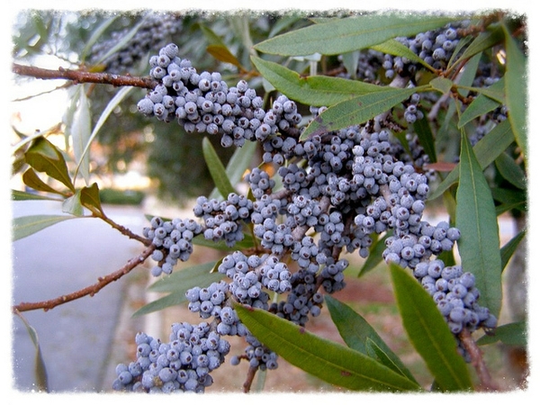
Southern wax myrtle (Myrica cerifera). Some of the reasons that wax myrtle thrives so well on the Outer Banks is that it is relatively tolerant of salt spray, high winds, and waterlogged soils. Photo courtesy, NC State Extension
Historically, the peoples of Early America, natives and newcomers alike, used wax myrtle for many different purposes.
Some used the leaves for seasoning soups and stews. Others used the root bark as an herbal medicine. Many others used the berries to make candles, soap and even plasters for wounds.

By the Alligator River, in what is now Tyrrell County, N.C., the map notes, “Rice grows Here.” Very little rice was cultivated in North Carolina at that time, but it later became an important export crop and the plantations where it was grown were some of the worst exploiters of slave labor. That was not so much in the vicinity of the Alligator River though, but nearly 200 miles to the south in the vicinity of Wilmington. Detail of Francis Veale’s 1730 map, Peter Collinson Commonplace Books, Linnean Society, London.
The making of candles out of myrtle wax was especially important on the North Carolina coast. It was a poor man and woman’s way of lighting a home, rivaled in its popularity only by the use of tallow, which was rendered from animal fat, and by the use of slivers of longleaf pine.
In his Natural History of Carolina, Florida and the Bahama Islands, the English naturalist Mark Catesby described the way that coastal families, especially those that were not well off, harvested wax myrtle berries and produced candles in the early 1720s.
“In November and December, at which times the berries are mature, a man with his family will remove from his home to some island or sand banks near the sea, where these trees most abound, taking with him kettles to boil the berries in.
“He builds a hut with Palmeto leaves, for the shelter of himself and family while they stay, which is commonly three or four weeks. The man cuts down the Trees, while the children strip off the berries into a porridge-pot, and having put water to them, they boil them till the oil floats, which is skim’d off into another vessel.
“This is repeated till there remains no more oil. This, when cold, hardens to the consistence of wax, and is of a dirty green colour. Then they boil it again, and clarify it in brass kettles, which gives it a transparent greeness. These candles burn a long time, and yield a grateful smell. They usually add a fourth part of tallow, which makes them burn clearer.”
A limited amount of myrtle wax was also exported to England from the southern colonies in the late 1600s and 1700s.
The Lost Towns and Villages
I found much of interest in Francis Veale’s map. However, what I found most striking about the map was not what is on it, but what is not.
Prior to the Tuscarora War in 1711, maps of the North Carolina coast still featured the towns and villages of the region’s Indian tribes and indicated their historic homelands.
For instance, the map that appeared in John Lawson’s New Voyage to Carolina in 1709 still showed Indian towns such as Chattoka and Wynoack on the North Carolina coast.
Lawson’s map also identified the territories of quite a few Indian tribes, including the Tuscarora, Nansemond, Machapunga, Coranine, Weetok and Occaneechee tribes.
Barely two decades later, in 1730, none of those Indian towns, and none of those Indian tribes, appeared on Veale’s map.

The maps tell the story: John Lawson’s 1709 map of the NC coast (seen here) lists Indian towns such as Chattoka and Wynoack as well as the more general locations of the Tuscarora, Nansemond, Machapunga, Coranine, Weetok and Occaneechee tribes. By 1730, none of them appeared on Veale’s map. From Lawson, New Voyage to Carolina (London, 1709). Courtesy, North Carolina Collection, UNC-Chapel Hill
Of course, before looking at Veale’s map, I knew that the British defeat of the Tuscarora and their allies in the Tuscarora War had been devastating to Native American society in the lands that the English came to call “North Carolina.”
I also understood that the war was not the only or even the first blow that led to the diaspora of the region’s native peoples. As early as the 1500s, an English expedition had burned a coastal Indian village and its crops near the Pungo River.
British colonists and the Chowanoac Indians, a far-ranging Algonquin tribe on the north side of the Albemarle Sound, had also been warring as early as the 1660s.
By 1700, a variety of plagues of infectious diseases brought to America by European ships had also taken a devastating toll on the native peoples of the North Carolina coast. In the case of the Pamlico Indians, for instance, a plague of one of those new diseases, smallpox, had left them on the edge of extermination by the 1690s.
(The Pamlico Indians were a relatively small tribe, apparently speakers of an Algonquian dialect, located south of the Pamlico River, in territory that is now Beaufort County and Pamlico County.)
Nonetheless, the Tuscarora War was still decisive. And there is something about seeing a map that does not even mention the Tuscarora or any of the coastal Algonquin tribes, especially a map drawn as early as 1730, that one cannot help but find gut wrenching.
Peter Collinson’s Commonplace Books
I found Veale’s map in one of the English botanist Peter Collinson’s commonplace books at the Linnean Society’s library. That is the same library where I found the 1757 letter written in Brunswick Town, near Wilmington, N.C., that is the first known record of the Venus flytrap. That letter was the subject of an earlier post here.
Collinson is an interesting figure. A Quaker cloth merchant, he was an avid botanist, horticulturalist and gardener who served as something of a middleman for British naturalists around the world. Through his correspondence, he shared news of the latest discoveries, put scientists with similar interests in touch with one another, and shared the latest journal articles.

The “Pantego River or Pamlico” (what we now call the Tar River). Veale notes that that part of the colony was known for producing “an abundance of Pitch & Turpentine.” Made from the resin and wood of longleaf pine trees, the colony’s turpentine and pitch had been shipped to England since at least 1714. They were essential for shipbuilding and sailing ships, but turpentine was also valued as an illuminant, an ingredient in paints and for many other uses. The large majority of Britain’s supply eventually came from North Carolina’s forests, largely accomplished with the labor of enslaved Africans. Detail from 1730 Veale map, Peter Collinson Commonplace Books, Linnean Society, London.
He was also a patron to some of the most important 18th-century naturalists in the British colonies in North America.
Most notably, those American naturalists included the great Philadelphia botanist John Bartram and the English naturalist Mark Catesby, whom I quoted earlier about the production of myrtle wax candles.
Collinson also lent his support and encouragement to very different kinds of scientific work in the British colonies. In 1747, he even supplied some of the scientific equipment with which Benjamin Franklin did his first experiments on electricity.
* * *
Francis Veale sketched the map for Collinson just before Christmas 1730. I know little else about Veale. He is not heard of much in the historical record after that point and does not seem to have otherwise corresponded with Collinson.
The map was accompanied by a four-page description of the North Carolina coast that emphasizes the lack of religion among the colony’s English settlers (“I believe they know. . . not what it is”) and the colony’s trade and natural resources.
I first learned about the existence of the map and Veale’s written description of the colony, as well as their location at the Linnean Society, in an article that was published in the North Carolina Historical Review in April 1964. (You can find a copy here.) That article was written by UNC-Greensboro professor of botany Edmund Berkeley and his wife, a very accomplished amateur historian of science named Dorothy S. Berkeley.
And as is so often the case with historical maps and manuscripts, I was reminded yet again that we can learn a great deal from what is in them, but sometimes far more from what is not.
***

David, I have loved your posts from your explorations in London. Even have ordered Lawson’s book. Thank you for being a wonderfully eclectic historian!
LikeLiked by 1 person
I look forward to all your posts. Thank you for your interesting research!
LikeLike
Lived in Elizabeth City as a youngster. Moved to N Durham 2021. Love reading of the history of Carolina’s.
LikeLiked by 1 person
Wish there was an email button for sharing these articles.
LikeLike
Pingback: “mapping” thoughts… | Andersons of Colonial N. Carolina