
A logging crew in the East Dismal Swamp, historically one of the largest freshwater wetlands on the North Carolina coast, ca. 1910-12. Source: Surry Parker, Steam Logging Machinery (Pine Town, N.C., 1912). Copy, North Carolina Collection, UNC-Chapel Hill
I have written this as kind of an on-line history exhibit. The story starts with a short introduction, then features more than 40 annotated photographs and other images illustrating the last decades of an ancient swamp forest that was once located on the North Carolina coast.
For quite some time, I have been collecting historical photographs, maps, and manuscripts that document the lumber boomtowns and logging camps of the Pungo River and its hinterlands in the late 19th century and the early part of the 20th century.
After the Civil War, lumber companies bought thousands of square miles of forestlands on the North Carolina coast. As if out of nowhere, scores of lumber mill towns sprang up virtually overnight (only to vanish, most of them, when the forest was gone).
The lumber companies re-shaped the land, our most important towns, and even some of our most remote islands.
Logging camps seemed to be everywhere. Hundreds, maybe thousands, of miles of railroads were built: to move logging machinery into even the most remote swamp forests; to haul logs to mills; and to carry lumber, after it was milled, to northern seaports.
Canals were built to drain swamp forests. Lumber barges and schooners crowded local waterways.
For the sake of building America, coastal forests that had stood for centuries, and sometimes millennia, vanished.
I do not know to what I can compare that part of North Carolina’s coastal history. It was a frontier world, often almost lawless, dangerous, destructive, and, for some, liberating, all at once.
Thousands of people left farms and fishing boats and their old lives to make a go of it in the mills and logwoods.
And they came from all over: not just from local towns and villages, but Appalachian hollows, Great Lakes logging camps, and New York City tenement houses.
They included men and women with the scars of slavery still on their backs, Outer Banks fishing families, and immigrants fresh from Ellis Island, many of them speaking barely a word of English– all made their way to the lumber mill towns and logging camps.
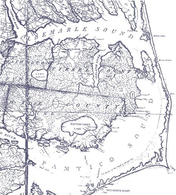
This 1808 map shows what is still the largest freshwater wetlands complex on the North Carolina coast. The dotted territory is swamplands, mostly pocosins, but also Includes river bottomlands, cypress and gum swamps, and other wetlands. We can see the Pungo River on the western side of Hyde County. We can also see the Pungo’s place within the larger, even more vast territory of freshwater wetlands that make up the Albemarle-Pamlico peninsula. Pocosins— an Algonquin word– are a unique kind of raised peat bog and make up the majority of five counties on that part of the North Carolina coast: Beaufort, Washington, Hyde, Tyrrell, and Dare. Taken together, they make up what Dr. John Paul Lilly, professor emeritus of soil science at N. C. State, has called “the largest pocosin in the world.” Jonathan Price et. al., This first actual survey of the state of North Carolina taken by the subscribers is respectfully dedicated…. (Philadelphia: C.P. Harrison, 1808). Courtesy, Library of Congress
In this collection of historical images today, I am focusing on the lumber boom in just one corner of the North Carolina coast– the Pungo and the forests within about 15 miles of its shores.
But I hope that by so doing, we can at least get a glimpse of the size and scale of the lumber boom throughout the North Carolina coast, what it was like for the people who lived through it, and how it transformed our communities, as well as our land and waters.
Rising in the central part of Washington County, in the remnants of what local people today often call the “Big Swamp,” the Pungo– an Algonquin Indian word– is only 35 miles long.
In its northernmost reaches, the river flows today through a canal that was dug in the 1950s to drain the farmlands west of Pungo Lake and what is now the Pocosin Lakes National Wildlife Refuge.
But then the river grows wild again. It meanders south, passing along breathtakingly beautiful cane brakes and marshlands until it opens up into a broad bay, an estuary really, that eventually folds itself into the Pamlico River and the Pamlico Sound.
Today it is a quiet, peaceful place. Belhaven, the only town on the river, has a population of less than 1,500. Pantego (another Algonquin name), the only town on any of the river’s tributaries, has maybe a few more than 200 residents.
It is a place of rural byways and little crossroads: when you leave Belhaven, you can go 25 miles in any direction– east, west, north, or south– and never hit a stoplight.
But as you will see here, the Pungo was once a very different place.
As you look through these old photographs and yellowed maps, please know that I am, as people sometimes say, a “lifetime learner.” I would always welcome hearing from anyone who might know more about any of these images.
In studying the Pungo’s lumber boom, one thing is very clear to me though: whatever other stories I tell, anything I write will also be an elegy. It just has to be.
The Pungo River was once the heart of one of America’s great natural wonders. When you left the river’s shores, you entered a vast wilderness, a swamp forest that covered hundreds of square miles and was so large and so foreboding that it had long been a refuge for the local Algonquin people, fugitive slaves, and other outcasts.
For those who care about our natural heritage, it was a marvel: the East Dismal Swamp– as I am going to call it– was home to ancient and majestic groves of bald cypress, some of the country’s largest stands of Atlantic white cedar (juniper), and pocosin wetlands of a size and grandeur found in few other places on Earth.
But especially between 1880 and 1920, the logging companies and land developers did not just log the Pungo’s old-growth forests: they erased them.
Using railroads and new kinds of machinery, they logged even the most remote corners of the East Dismal. Then– especially in the pocosins– they dug great canals and vast networks of ditches to drain the land. When the peat soils dried out, they then burned what was left of the forest and the peat beds again and again.
They did that until the East Dismal Swamp– or whatever you want to call that great swamp wilderness– was gone.
If you visit the site of the East Dismal today, you will find only a broad, open plain and seeming endless farm fields, stretching, in many places almost treeless, as far as the eye can see.
You might think that you were in Kansas or Nebraska, if it were not for the miles and miles of canals and ditches.
History is for me, when all is said and done, about remembrance and recalling the ancestors.
And through them, coming to know ourselves.
But there are also times when I think that we should remember lost places, out of respect for them and maybe for our own good, too. I think that this is one of those times.
-1-
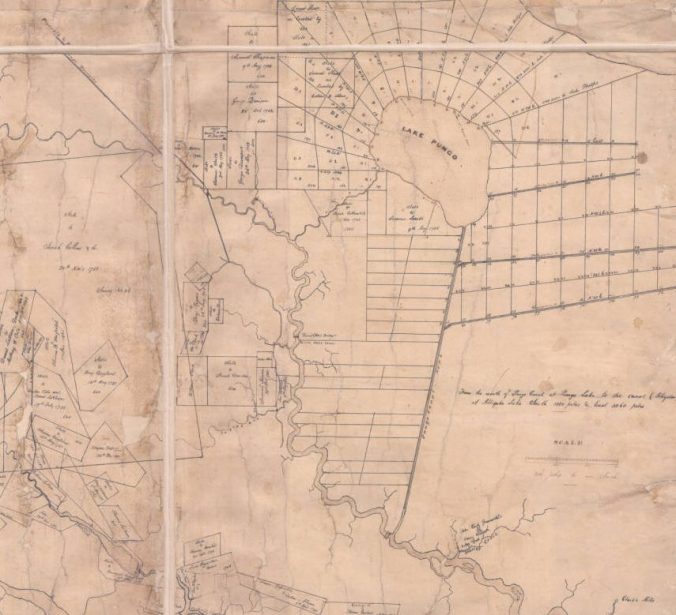
This survey is the earliest detailed map of the East Dismal Swamp that I have seen. Dated 1844, it shows the holdings of the Albemarle Swamp Land Company, a Virginia lumber company that had purchased approximately 100,000 acres of the East Dismal in 1840. The company had bought the land from the heirs of Josiah Collins (1735-1819), a wealthy planter who operated what amounted to a massive slave labor camp at Lake Phelps, 10 miles east of the Pungo River. At that site, Collins forced hundreds of Africans and their children and grandchildren to hew an agricultural plantation out of a vast pocosin swamp. Southern agricultural leaders widely considered his plantation at Lake Phelps to be a pioneering model for turning pocosin swamplands into agricultural fields. A central lesson of his experience, however, was that, at least at that time, it could only be done with large numbers of slave laborers and at the cost of an enormous amount of human suffering. On this map, we can see two major infrastructure projects that enslaved Africans and their descendants were forced to build in the vicinity of the Pungo River: the Pungo Canal, which runs out of Pungo Lake a distance of 6 and 1/2 miles to the Pungo River, and the Plymouth & Pungo Turnpike (in the map’s top left corner). Both projects helped to open up the East Dismal to logging after the Civil War. Source: Washington W. Hayman, “A Map of the Albemarle Swamp Land Company’s Lands… near Lake Pungo and Pungo River” (1844). Courtesy, State Archives of North Carolina
-2-

Map of the Albemarle & Pantego Railroad (G. W. and C. B. Colton & Co.), 1887. Courtesy, Library of Congress. The shaded portion of the map shows the approx. 140,000 acres of the East Dismal Swamp that the John L. Roper Lumber Co. first leased and later acquired from the Albemarle Swamp Land Company ca. 1880. Prior to the Civil War, an unknown but not insignificant part of that swamp forest had been selectively logged at least once (largely by enslaved laborers). Once in possession of the land, the Roper Lumber Co. built the Albemarle & Pantego Railroad to serve as the backbone for its far more extensive logging operations on that part of the N.C. coast. The Norfolk & Southern Railroad– of which John L. Roper was a principal investor and officer– purchased the railroad and expanded the line from Mackey’s Ferry to Belhaven ca. 1891.
-3-

This is logging railroad built through an Atlantic white cedar swamp forest 8-10 miles northeast of the Pungo River’s headwaters, ca. 1900-1907. The railroad carried logs to the John L. Roper Lumber Co.’s cedar mill in Roper, in Washington County, N.C. The abundance of Atlantic white cedar (Chaemaecyparis thyoids), also known as juniper, was one of the most compelling reasons that the John L. Roper Lumber Co. purchased more than 100,000 acres in the East Dismal Swamp ca. 1880. Atlantic white cedar are evergreen coniferous trees native to peaty swamps and bogs in a narrow coastal belt running from southern Maine to Mississippi. No tree was more valued by lumber companies on the North Carolina coast. Because it is lightweight, resistant to water decay, and straight grained, the wood of Atlantic white cedars has historically been used for making shingles, shakes, posts, and other building materials, as well as for the construction of tubs, pails and other woodenware. It was also the preferring wood for North Carolina’s boat builders, and remains so today. Because of the wood’s desirability and the high prices it brought, lumber companies targeted Atlantic white cedar forests with special vigor. Photo from American Lumberman, 27 April 1907.
-4-

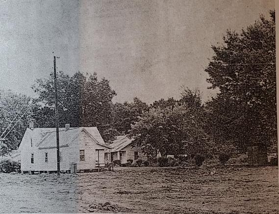
This is a remote labor camp called Wonderland, on the border of Washington County and Beaufort County, N.C., November 1917. The railroad tracks are those of the Norfolk & Southern. On the left, we can see a commissary and post office being built. On the right, we can see barracks for some of the hundreds of black workers that were employed in logging, clearing, and burning and re-burning what was left of the East Dismal Swamp. After logging the swamp forest, the Roper Lumber Co. had sold 40,000 acres of its holdings in the East Dismal to Mark W. Potter, a wealthy New York attorney who was president of the Ohio, Clinchfield & Carolina Railway Co. (a subsidiary of the Norfolk and Southern). Going into business with local lumbermen and land developers John A. and Samuel Wilkinson (more on them later), Potter aimed to reclaim the logged swamplands, subdivide the land, and sell plots to farmers recruited mainly in the Midwestern states. However, according to federal records, Wonderland only had a post office from 1917 to 1925. Once the ground was made ready for farming, the little settlement disappeared and was soon forgotten. Other land developers attempted similar projects on the Roper Lumber Co.’s former holdings. According to a WPA interview with Samuel Wilkinson in 1938, most, including the Wilkinson brothers, ended up making little if any profit, in large part due to the ongoing costs of draining the land. By the time that they added up their losses however, only a scattered few thousand acres of the East Dismal had not been logged, drained, burned repeatedly, and turned into farmland. From Views of Potter Farms Development: Showing Various Stages in the Evolution of Potter Farms (1917), North Carolina Collection, Wilson Library, UNC-Chapel Hill
-5-

In 1913, Samuel Wilmer, a correspondent for the Manufacturers Record in Baltimore, visited one of John A. and Samuel Wilkinson’s drainage projects in the East Dismal Swamp. The Wilkinson brothers had bought a 20 or 25,000-acre tract of heavily logged swampland from the Roper Lumber Co. to convert it into farmland for their own profit. Wilmer wrote: “Back in the woods . . . is a big steam dredge built by the American Steam Dredge Co., Fort Wayne, Ind., working night and day…. It is operated by two crews, one of whom sleeps in a houseboat attached while the other works.” The Wilkinsons’ two dredges dug many miles of canals through the section of the East Dismal northwest of Pantego (in the area that became the community of Terra Ceia) and also along the main line of the Norfolk & Southern, on and around the border of Hyde and Washington counties. Their dredging crews dug the main canals 20 feet across and 8 feet deep and located them a mile apart. Since that time, the drainage of those freshwater wetlands into the Pungo River watershed has had a profound effect on water quality in the Pamlico Sound and on the estuary’s commercial fisheries. Photo from Samuel G. Wilmer, “New Railroad and Drainage Work,” Manufacturers Record (Baltimore, Md.), 1 Jan. 1914
-6-

This is a somewhat later view of one of the Wilkinson brothers’ dredges at work in the swamp forests near the Pungo River, ca. 1918. In an interview 20 years later, when he was almost 80, Samuel Wilkinson described the birth of Terra Ceia, a farming settlement built on the the remains of an old growth swamp forest northwest of Pantego. He told the interviewer, Muriel Wolff: “When I was a boy all that land over there wasn’t anything but swamp. It was full of great big cypress and juniper trees, timber that never had been cut. Well, back in 1905 I was working for the Roper Lumber Company, located over in Belhaven, and they started logging that swamp. To do that they had to dig ditches and drain off some of the water, but it still wasn’t fit for anything when me and my brother bought up 20,000 acres in 1911…. If you don’t believe we spent the money, I’ll tell you what we had to do. That was swamp land, remember, and ditches wouldn’t drain off all the water. There had to be 40 miles of canals besides the ditches. We paid $20,000 for a dredge to dig canals. It broke after the first seven miles. We bought another but it broke too before we finished. Then we had to put through a branch line of the railroad—11 miles of it at $1,000 a mile. Before we could lay a track we had to buy the right of way and buy $70,000 worth of Norfolk & Southern stock. But we got the railroad through.” Ms. Wolff’s interview can be found in the Federal Writers’ Project Papers at the Southern Historical Collection at UNC-Chapel Hill. Photo source: Cut-Over Lands vol. 1, #4 (July 1918).
-7-
![According to the Raleigh <em>News & Observer</em> (28 August 1910), the process that John A. and Samuel Wilkinson used to turn old-growth swamp forests into farmland had been used on a much smaller scale in the East Dismal since before the Civil War. The <em>N&O's</em> correspondent wrote: "<em>Here for 75 years the people have removed the merchantable timber, cut down the remainder of the growth in the summer and fall and left it to dry out until early spring.... [They then] set fire to it so that a terrible fire has destroyed it all, leaving over the rich earth a mass of ashes and such charred poles and stumps as would soon decay...." </em>The fires were great conflagrations: most of the East Dismal was a pocosin, a kind of raised peat bog, and the peat, used as a fuel in many parts of the world, was sometimes as much as 10-12 feet in depth. When drained, the upper layers of the peat dried out and grew especially combustible, leading to fires of almost unimaginable fury and devastation. While a long-standing practice, the Wilkinsons applied that method of swamp reclamation on a much larger scale by introducing the use of steam dredges, railroads, and mechanical logging equipment. <em>"Day and night their labors and the labors of hundreds of employees, three locomotives, two dredges and five skidding machines have been wiping out the forest and transforming the great Albemarle swamp...."</em> The not-very-good photo above (from the same issue of the <em>N&O</em>) shows one of the canals that their dredges dug through the swamp.](https://davidcecelski.com/wp-content/uploads/2023/09/img_0978-e1695086668875.jpg?w=676&h=478)
According to the Raleigh News & Observer (28 August 1910), the process that John A. and Samuel Wilkinson used to turn old-growth swamp forests into farmland had been used on a much smaller scale in the East Dismal since before the Civil War. The N&O’s correspondent wrote: “Here for 75 years the people have removed the merchantable timber, cut down the remainder of the growth in the summer and fall and left it to dry out until early spring…. [They then] set fire to it so that a terrible fire has destroyed it all, leaving over the rich earth a mass of ashes and such charred poles and stumps as would soon decay….” The fires were great conflagrations: most of the East Dismal was a pocosin, a kind of raised peat bog, and the peat, used as a fuel in many parts of the world, was sometimes as much as 10-12 feet in depth. When drained, the upper layers of the peat dried out and grew especially combustible, leading to fires of almost unimaginable fury and environmental devastation– and capable of burning, in some cases, for months. While adopting a long-standing practice, the Wilkinsons applied that method of swamp reclamation on a much larger scale by introducing the use of steam dredges, massive canal digging projects, railroads, and mechanical logging equipment. “Day and night their labors and the labors of hundreds of employees, three locomotives, two dredges and five skidding machines have been wiping out the forest and transforming the great Albemarle swamp….” The not-very-good photo above (from the same issue of the N&O) shows one of the canals that their dredges dug through the swamp.
-8-
![African American workers in the East Dismal, ca. 1910. They were preparing to plant "stick corn" near Wonderland. In July 1918, a journal called Cut-Over Lands (vol. 1, #4) described how the Wilkinson brothers used the planting of stick corn at Potter Farms and in Terra Ceia as the final step in converting the swamp forest into agricultural fields: "About May 1st, after the cutting [of the forest], the entire area is burned over, the fire consuming all small stuff and partially consuming the larger logs and stumps. Immediately after the burn, corn is planted among the logs and stumps by the "stuck corn" method, without plowing. The work is done chiefly by negro men and women and consists of dropping the seed in a hole made with a small stick.... Native labor (chiefly colored men and women) gather the corn in the fall and bring it to the ditch banks, from which it is carted to the cribs. After the corn is gathered, the stalks are cut down, and about May 1st of the following year-- the stalks serving as kindling-- the land is again burned over, further consuming the logs and stumps which have had a year's drying since the first burn. The consumption of the stumps is facilitated by the fact that the soil in settling after the removal of the water through the ditches, draws away from the upper portions of the roots, permitting the fire to attack them and work under the main portions of the stumps. After the removal of the second or third crop . . ., the remaining sticks and portions of logs and root snags are piled and burned."](https://davidcecelski.com/wp-content/uploads/2023/10/img_1359-e1698627236631.jpg?w=676&h=303)
African American workers in the East Dismal, ca. 1910. They were preparing to plant “stick corn” near Wonderland, the labor camp at Potter Farms. In July 1918, a journal called Cut-Over Lands (vol. 1, #4) described how the Wilkinson brothers used the planting of stick corn at two locales near the Pungo River– Potter Farms and Terra Ceia– as the final step in converting the swamp forest into agricultural fields: “About May 1st, after the cutting [of the forest], the entire area is burned over, the fire consuming all small stuff and partially consuming the larger logs and stumps. Immediately after the burn, corn is planted among the logs and stumps by the “stuck corn” method, without plowing. The work is done chiefly by negro men and women and consists of dropping the seed in a hole made with a small stick…. Native labor (chiefly colored men and women) gather the corn in the fall and bring it to the ditch banks, from which it is carted to the cribs. After the corn is gathered, the stalks are cut down, and about May 1st of the following year– the stalks serving as kindling– the land is again burned over, further consuming the logs and stumps which have had a year’s drying since the first burn. The consumption of the stumps is facilitated by the fact that the soil in settling after the removal of the water through the ditches, draws away from the upper portions of the roots, permitting the fire to attack them and work under the main portions of the stumps. After the removal of the second or third crop . . ., the remaining sticks and portions of logs and root snags are piled and burned.”
-9-

This is a logging crew and a logging machine called a “skidder“ finishing off a section of black gum (Nyssa sylvatica, also called “tupelo gum”) swamp forest near the Pungo River, ca. 1907-1912. In 1910 a reporter visited one of the Wilkinson brothers’ logging crews in the East Dismal and described a skidder’s operation. He wrote: “By and by, . . . the position of the`skidder’ was revealed by clouds of steam and the voices of the loggers became audible. Then around an abrupt curve the odd machine came into view as it tugged away at a heavy log some distance off to one side…. A wire rope more than 100 yards long and with a hook at its free end was hitched about the log and the drum of the `skidder’ was winding up the stout cord while the heavy piece of timber came smashing through the undergrowth, mowing down brush and breaking and crushing the saplings. . . .There is something thrilling about seeing one of these big logs pulled by the rope, come tumbling through the bushes and smaller timber as lightly almost as if it were a toothpick. . .. From the woods, by means of the tram road, the logs are gotten out and sent to the mills in Belhaven, where . . . they are speedily cut up into lumber for building and other purposes, including the manufacture of blocks for street paving, the black gum wood being found suitable for the latter purpose.” (Republished from the Manufacturers Record in the Raleigh News & Observer, 28 Aug. 1910.)
-10-

The John L. Roper Co. and the Wilkinson brothers were not the only lumber interests at work in the vicinity of the Pungo River. There were probably 10 or 12 lumber mill boomtowns and scores of logging camps located within 15 miles of the Pungo between 1870 and 1930. On this map, for instance, we see the logging village of Waring (later known as Dymond or Dymond City) and the Jamesville & Washington Railroad and Lumber Co.’s extensive land holdings ca. 1890. Located several miles west of the Pungo, the 21-mile-long railroad– known whimsically as the “Jolt and Wiggle”– was built– like all the region’s railroads– primarily for logging and the lumber trade. In the case of the J&W, the purpose of the railroad was to carry logs to its mill in Waring and then to carry lumber that was milled in Waring to freight vessels in Jamesville, on the Roanoke River, or in Washington, N.C., on the Pamlico River. On the map, note the large stands of bald cypress and Atlantic white cedar (juniper) in those swamp forests, especially northeast and southeast of Waring and in the headwaters of Deep Run Creek. According to a Feb. 3, 1963 article in The State, Waring was settled principally by Quakers and had a sawmill, a 32-room boardinghouse, a 3-story company store, worker housing, and a railroad shop. Since its abandonment, Dymond– as it is usually remembered today– has been the subject of more than a few ghost stories. F. Lightfoot, “Map of the Jamesville and Washington Railroad & Lumber Co.’s Land and Railroad,” ca. 1885-1905, Getsinger Family Papers, ECU Digital Collections
-11-

Established in Belhaven in 1905, the Interstate Cooperage Co. was the largest mill on the Pungo River in the early 20th century and was one of the largest lumber mills anywhere on the North Carolina coast. In the early 1900s, the company acquired the rights to hundreds of thousands of acres of forestland in at least Hyde, Beaufort, Carteret, Craven, and Jones counties, including a large part of what is now the Croatan National Forest. The company’s property on the Pungo included a sprawling sawmill, dry kilns, a stave mill, a barrel factory, and what was said to be the largest box factory in the world. Among much else, Interstate turned out the barrels and pallets that its owner, Standard Oil (the world’s largest petroleum company at that time), used for shipping petroleum. Somewhere between 600 and 900 workers, the vast majority of them African American, worked at the company’s mill in Belhaven, while many more toiled in its logging camps. Among its workers were also recent immigrant laborers brought south by labor agents. Lumber and railroad companies in the vicinity of the East Dismal employed sizable numbers of Russian, Polish, Italian, Greek, Hungarian, Latin American, and other immigrants, especially between 1900 and 1925. Postcard from the Moore Family Papers, East Carolina University Digital Collections
-12-
![In its Oct. 2, 1874 issue, the Tarboro Enquirer Southerner printed a letter that describes the Albemarle Swamp Land Company's logging and lumber operations in the village of Pantego and elsewhere along the Pungo River. The newspaper's correspondent-- he signs his letter "Zara."-- wrote: "The Albemarle Swamp Land Co. have their headquarters here, they own a first rate grist mill (water) and a sawmill in operation during the rainy seasons. They make a large quantity of juniper shingles on their lands, which are brought to this place by carting to the river, they are then floated 10 miles and then brought the balance of the way (5 miles) on a railroad with a mule for an engine and a negro boy for conductor and engineer. I suppose the Company ship[s] near a million of pieces annum. Vessels large enough to sail to Philadelphia and New York can come to within 4 or 5 miles, which distance the shingles are carried in large flats." The Albemarle Swamp Land Co. had purchased a large part of the East Dismal Swamp from the heirs of Josiah Collins, a wealthy land baron and one of the most notorious enslavers of Africans and their descendants on that part of the N.C. coast. The John H. Roper Lumber Co. eventually bought out the company's land holdings.](https://davidcecelski.com/wp-content/uploads/2023/09/img_0974-e1695055067282.jpg?w=430&h=577)
Prior to and immediately after the Civil War, the Albemarle Swamp Land Company was the largest logging operation in the East Dismal Swamp. Chartered in 1840, the company’s shingle and lumber mills, blacksmith shop, and worker housing were all located in Pantego, a small village on Pantego Creek, a tributary of the Pungo River. The company owned approximately 100,000 acres of swamp forest, most of it in the headwaters of the Pungo River and east toward Alligator Lake. In its Oct. 2, 1874 issue, the Tarboro Enquirer Southerner printed a letter that describes the company’s operations after the war, when it still relied on wooden railroad track with logging cars hauled by mules. The newspaper’s correspondent– he signed his letter “Zara.”– wrote: “They make a large quantity of juniper shingles on their lands, which are brought to this place by carting to the river, they are then floated 10 miles and . . . brought the balance of the way (5 miles) on a railroad with a mule for an engine and a negro boy for conductor and engineer. . .. Vessels large enough to sail to Philadelphia and New York can come to within 4 or 5 miles, which distance the shingles are carried in large flats.” The John H. Roper Lumber Co. later bought out the company’s land holdings.
-13-

According to local historian Elizabeth Parker Roberts, loggers used oxen to haul high-wheeled carts laden with Atlantic white cedar (juniper) logs out of the Pike Road section of the East Dismal Swamp beginning in the 1890s. As discussed above, the Albemarle Swamp Land Co. had earlier used a similar, if somewhat rougher route to transport logs to its mills in Pantego: first using oxen and probably horses to haul logs out of swamplands to the Pungo River, then floating the logs down the river to a creek called Indian Run. At a landing on Indian Run, they loaded the logs onto railroad cars that were pulled by mules over hand-hewn wooden rails to Pantego, a distance of 4 miles. The company sent its finished shingles, staves and other products from Pantego to a wharf on the Pungo River over a similar rail system. According to a letter from Pantego published in the Democratic Advocate, in Westminster, Maryland (12 Mar. 1871), the company shipped its products directly to Philadelphia and Providence, Rhode Island. Photo courtesy, W. Mayo. Originally published in Elizabeth Parker Roberts, Family and Friends: Pine Town, North Carolina, 1893-1918.
-14-

On this 1844 survey map, we can see the blackwater creek known as Indian Run and the point where it flows into the upper part of the Pungo River. The Albemarle Swamp Land Company’s mule-powered railroad ran from Indian Run several miles southwest to the company’s shingle mill in the village of Pantego. The surrounding lands were pocosins, bald cypress swamps, and other wetlands. Detail from Washington W. Hayman, “A Map of the Albemarle Swamp Land Company’s Lands… near Lake Pungo and Pungo River” (1844). Courtesy, State Archives of North Carolina
-15-

A view of the John L. Roper Lumber Co.’s planing mill on the Pungo River at Belhaven, N.C., ca. 1907. In its early days, Belhaven was a company town bought, built and run by a railroad– the Norfolk & Southern– and a company– the John L. Roper Lumber Co.– that were both bent on making a fortune logging the ancient forests in and around the East Dismal Swamp. Prior to 1890, a little oystering village called Jack’s Leg was all that was located on that part of the Pungo. That changed almost overnight. The area’s transformation began when the Norfolk & Southern ran a line to Jack’s Leg. The railroad’s president then financially backed a local farmer and veteran lumberman named John A. Wilkinson to establish a new lumber mill on that part of the Pungo River. That mill would become part of the John L. Roper Lumber Co.’s empire. Wilkinson and his brother Samuel, with whom he often partnered in business matters, knew the southern part of the East Dismal like few others: they had grown up in a small farming settlement called Wilkinson that is a few miles northwest of Belhaven, on the edge of Pantego Swamp. Samuel Wilkinson continued to farm there throughout his life. Photo courtesy, American Lumberman, April 27, 1907.
-16-
The John L. Roper Lumber Co.’s power plant, Belhaven, N.C., ca. 1906. In 1893, with the arrival of the railroad and the construction of the Roper Company’s mill, Jack’s Leg was rechristened Belhaven. Within a year, the town’s population rose from 78 to 700. In addition to the sawmill and planing mill, John H. Wilkinson and his brother Samuel established a company store, an ice plant, a light and power plant, and other businesses. Whole neighborhoods of shanties, shotgun houses and boardinghouses– West Belhaven, Black Bottom, Rittertown– were built. Within a few years, Belhaven was home to a half-dozen lumber mills. Lumber barges and log rafts crowded the Pungo. Visitors reported that the whistle of the Norfolk & Southern’s log trains could be heard night and day, seven days a week. Even during the Great Depression, as many as a thousand carloads of lumber left the town by rail a year. Courtesy, H. H. Bromley Collection, State Archives of North Carolina
-17-

Stock certificate for the Roanoke Railroad & Lumber Co., 1928. In the 1880s, a Philadelphia lumber baron named Clarence Branning established a lumber mill village called Bayside on the Pamlico River, 12 miles southwest of Belhaven. His company also built a logging railroad, the Bayside & Yeatesville, that connected the mill to timber holdings in Yeatesville, Bath, and Pamlico Beach. Branning sold the mill, railroad, and the village– “everything except the walnut desk belonging to Mr. Branning,” according to one source– to the Roanoke Railroad & Lumber Co. in 1887. Life in Bayside revolved around the mill and the lumber trains until 1919, when the mill burned. After the company left Bayside for good, the village’s name was changed to Bayview and it gradually became the little community that it is today. Note: According to a reminiscence later published in the Nashville Graphic (Nashville, N.C., 23 June 1953), the Roanoke Railroad & Lumber Co. brought in “Russian, Italian and Arabian workers” to work at its mill in Momeyer, in a different part of eastern N.C. I would expect that the company also employed a significant number of immigrant laborers at its mill in Bayside.
-18-

The John L. Roper Lumber Co.’s company store in yet another lumber boomtown– Roper, 10 miles north of the Pungo’s headwaters, ca. 1907. Lee’s Mill– the name of the settlement until the company arrived in 1889– had been the site of small-scale shingle and lumber mills since the 1700s. Prior to the Civil War, local milling companies loaded their wood products onto flatboats and floated them down Kendrick Creek to the Albemarle Sound, where they were transferred onto sloops and schooners for shipment north. When the John L. Roper Lumber Co. and the Norfolk & Southern Railroad arrived however, everything changed, including the village’s name. Hundreds of new residents moved to Roper to work in the company’s mills. Electric lights illuminated the streets. Shops, boardinghouses, inns, and taverns and the like opened in the booming village, as did the impressive company store that we see here, which was part grocery, part hardware store, part pharmacy, and part bank (or perhaps more accurately, part payday lender). Trains came and went several times a day, and the voices of people from all over the U.S. and other nations could be heard in the village streets. Photo from American Lumberman, April 27, 1907.
-19-

The John L. Roper Lumber Co.’s Atlantic white cedar (juniper) mill in Roper. The town of Roper was a lumber mill boomtown renown especially for this mill, said to be the largest cedar mill in the United States at that time. Moving left to right, we can see the mill’s water tower, power plant, the cedar sawmill, railroad cars, and the Norfolk & Southern’s spur that led into the mill. On the near side of the tracks, we can see stacks of cedar shingles and laths. Railroads were central to all lumber companies on the North Carolina coast at that time: to move its logs and lumber, the Roper Lumber Co. is estimated to have built somewhere between 150 and 200 miles of railroad. The Roper plant had the company’s only mills that relied entirely on railroads for log deliveries– at the company’s other mill sites, logs also arrived by water. Roper, unlike so many of the lumber boom towns, has found new life and is an incorporated town today, though it has been a long time since it was as bustling as it was when the Roper Lumber Co.’s mill was still in business. American Lumberman, April 27, 1907.
-20-

Atlantic white cedar (juniper) shingles at the John L. Roper Lumber Co.’s mill in Roper, N.C. In the 19th century, cedar shingles and shakes grew to be the most widely used roofing material on public buildings and residences in the U.S. By most accounts, the Roper company’s mill on the north side of the East Dismal was the country’s largest supplier of shingles in the late 19th and early 20th century. The impact of the company’s logging on the Atlantic white cedar forests of eastern N.C. was staggering: According to forestry researchers, more than half of the Atlantic white cedar forests in eastern North Carolina were cut down between 1880 and 1900, the bulk of them by the John L. Roper Lumber Co. and the Richmond Cedar Works (which operated in the vicinity of the Alligator River). Very little, if any, of the Atlantic white cedar forests around the Pungo have survived to the present day. According to the N.C. Forest Service, 95% of the state’s Atlantic white cedar swamps have been lost over the last 120 years. The largest surviving white cedar forests in North Carolina, and probably the largest in the world, are now located in the Alligator River National Wildlife Refuge, in Dare County, N.C. Photo from the American Lumberman, 27 April 1907
-21-

This is a logging railroad through a black gum swamp forest roughly 10 miles northeast of the Pungo River’s headwaters, ca. 1900-1907. Black gum (Nyssa sylvatica)— also known as tupelo, tupelo gum or sour gum– flourished in the swamp forests along the Pungo’s shores and throughout much of the North Carolina coast. A deciduous species of medium height, black gum trees can sometimes live more than 500 years. Their early-ripening fruit plays an especially important role as a food source for migrating birds in the fall, and of course “tupelo honey” is widely treasured. Tough, cross-grained, and difficult to split, the wood has historically been used to make railroad ties, paving blocks, mauls, pulleys, and the like. In North Carolina’s coastal villages, black gum was also a preferred wood for making pound net stakes, net floats, and waterfowl decoys.
-22-

Even lumber mills some distance from the Pungo exploited the East Dismal’s swamp forests. One of them was that of the Eureka Lumber Co., which for many years was the largest lumber mill in Washington, N.C. One of the company’s sources of logs was the Pungo River. The company’s lumbermen shipped logs from the Pungo up the Pamlico River to its mill (seen here), a distance of about 30 miles, and also east from extensive land holdings well up the Tar River. In 1904-08, the company also ran a logging railroad 40 miles southeast to Vandemere, in Pamlico County. Organized in 1892, the company specialized in producing, among other things, the wooden beams that held up mine shafts. Photo courtesy, Sabin Leach
-23-

A crew of the John H. Roper Lumber Co.’s loggers using a steam skidder in a section of the East Dismal 9 or 10 miles northeast of the Pungo River’s headwaters. A technological revolution in logging technology may have been the first note in the East Dismal’s death knell. The industry’s adoption of steam power and railroads in the late 1800s meant that logging no longer had to occur in the proximity of a waterway: railroads could reach into the interior of swamp forests, and logs and logging machinery could be moved by rail. The first successful steel-railed logging railroad in the U.S. was built in 1876– and the number of those logging roads in the U.S. rose from zero to 30,000 by 1910. Steam skidding (as we see in this photograph) and the first widely used steam-powered log loaders only appeared in the 1880s. Innovations in crosscut saws– the invention of raker teeth and the use of tempered steel blades– also made logging more efficient. (Gasoline powered chain saws were not widely used until after World War Two.) Especially when combined with the use of steam-powered dredges to drain wetlands and make them more accessible to loggers, those developments meant that forests such as those in the East Dismal, that had previously seemed far less vulnerable to large-scale commercial logging, were suddenly in danger. American Lumberman, April 27, 1907.
-24-

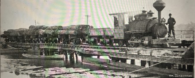
A locomotive hauling a load of logs out of a swamp forest near the Pungo River, ca. 1910-12. Surry Parker, a designer and builder of steam logging machinery, published this photograph in his company’s 1912 catalog to illustrate how the use of railroads and steam logging machinery opened up even the soggiest parts of swamp forests to logging. Source: Surry Parker, Steam Logging Machinery (Pine Town, N.C., 1912). Copy, North Carolina, UNC-Chapel Hill
-25-

Technological innovations in sawmills were no less important to the East Dismal’s fate than those in logging. In the late 1800s, the introduction of steam feeds, log rollers, dry kilns, band saws (like this one at the John L. Roper Lumber Co.’s cedar mill in Roper, N.C.), mechanical carriers, so-called endless chains (for bringing logs into mills) and planing machines, among much else, all dramatically increased the milling capacity of sawmills, with far-reaching consequences for forests such as those in the East Dismal. Photo from American Lumberman, April 27, 1907.
-26-

In the late 19th and early 20th centuries, another cluster of lumber mill towns and logging camps was located on the east side of the Lower Pungo. This is a hand-drawn map of Berkley, a hard-drinking, hard-living shanty town that was home to many of the Scranton Land and Lumber Co.’s African American workers. It sat on the north side of Scranton Creek, opposite the site of the company’s mill and the village of Scranton, yet another of the Pungo’s lumber boom towns. (Scranton Creek flows into the Pungo 8 miles upriver of Belhaven.) Chartered in Scranton, Penn., in 1889, the company had large land holdings on the east side of the Pungo in the 1890s. Local historian Morgan Harris recalled that Berkley had a reputation for being a refuge for drifters and the dispossessed, though of course one could say that of many logging camps and lumber mill villages in those days. Map courtesy, Morgan H. Harris, Hyde Yesterdays: A History of Hyde County
-27-

Makleyville was another village that grew up around the Scranton Land and Lumber Co.’s operations on the east side of the Lower Pungo. It was located where Slade Creek flows into the Pungo, several miles downriver of Belhaven. The Makleyville Hotel (seen here) served as the village’s hotel, boardinghouse, company store, and post office. Local buildings included sawmills, dry kilns, barracks for the largely African American workforce, a pair of warehouses, and a long wharf that reached into the Pungo. Most of the mill’s buildings were built on sawdust mounds and wharf pilings. Ethel Ayers Gibbs, the daughter of the hotel’s managers, recalled that she had “seen as many as six and eight big barges from Baltimore up at the mill loading at a time.” Makleyville was a bustling little town in its time, and a regular stop on the steamer lines that ran between Edenton and Washington, N.C. Like so many other lumber boomtowns, the town vanished after the last of its mills shut down. This photograph originally appeared in a 1949 article in the Belhaven Times by Ethel Ayers Gibbs and was re-published in the Beaufort-Hyde News (Belhaven, N.C.), 13 March 1980.
-28-

In 1899 life in Scranton revolved around the Alleghany Lumber Co.’s mill, purchased along with an estimated 100,000 acres of forestland from the Scranton Land and Lumber Co. ca. 1892-95. This is a page from a daily account book of the company’s workers and hours. Note the central role of railroad construction in logging in the forests along the Lower Pungo. On the day shown here– — May 29, 1899– roughly a quarter of the company’s workforce was building railroad spurs into the company’s forestlands. The company used those railroads to transport steam-powered skidders and loaders into even the most remote parts of the forest, and also used to them to haul logs back to the company’s mill in Scranton. After a section of forest was logged, workers would tear up the rails and run new lines into uncut parts of the forest. From Allegheny Lumber Co. Account Book, Outer Banks History Center
-29-
Log train coming into the John L. Roper’s lumber mill in Scranton, ca. 1907. American Lumberman, 27 April 1907
-30-

This is a hand-drawn map of still another lumber mill village that was located in the vicinity of the Pungo River. The village’s name was Burrell, and it was the site of the Burrell Lumber Co.’s mill on the upper part of the Pungo River, ca. 1920s/30s. The village was located on the New Holland, Higginsport, and Mount Vernon Railroad, a 35-mile-long spur that ran from the Norfolk & Southern’s main line in Wenona to Lake Mattamuskeet. As you can see on the map, Burrell included, besides the company’s mill, a company store, a railroad station, and a large barracks for housing mill workers and loggers. According to local lore, Davis Landing (on the map just below the Burrell mill store and barracks) was the site of an Algonquin Indian village late into the 19th century. That village seemed to vanish with the forest. Courtesy, Morgan H. Harris, Hyde Yesterdays: A History of Hyde County
-31-

Documentary sources tell us frustrating little about what daily life was like for the loggers, sawmill workers, and railroad builders who worked in the vicinity of the Pungo. One exception is a collection of newspaper accounts, court records, and other historical sources related to the brutality and peonage-like conditions that the builders of the New Holland, Higginsport, and Mount Vernon Railroad faced in the early 1920s. Originating on the Norfolk & Southern’s main line in Wenona, the NHHMV ran through the lumber mill village of Burrell (site of Kirwan Station on this map) and on to Lake Mattamuskeet. Built primarily to supply coal to the pumping station in New Holland, the railroad also opened up a large section of swamp forest to logging. For more on the working conditions in the NHHMV’s work camps, see my recent story, “The Italian Workers: The Life and Times of the Immigrants who Built North Carolina’s Railroads.” This map is from The Official Standard Time of the Railways and Steam Navigation Lines of the United States, Porto Rico, Canada, Mexico and Cuba (July 1928).
-32-

For me headlines such as this– from the March 19, 1908 edition of the Washington Progress (Washington, N.C.)– show how much more I have to learn about the history of the region’s lumber industry workers. The story refers to a melee between local workers and immigrant workers at Interstate Cooperage’s mill in Belhaven that grew so violent that local officials called in the Washington Light Infantry to restore order. I do not fully understand the historical context for this conflict. However, what I suspect, based on a variety of other sources, is that the company’s leaders had recruited Greek immigrants in the northern states as a way of undermining an effort by the local workers to improve pay and working conditions at Interstate Cooperage. It was not an isolated incident. I have caught glimpses, but only glimpses, of labor strikes, walk-outs, and the violent repression of worker organizing at lumber mills elsewhere on that part of the North Carolina coast. I do not think that I know enough to say more than that, except that I think it would be a difficult, but potentially promising, area of historical research.
-33-

This scene is one of the John L. Roper Lumber Co.’s log re-loading stations on the Norfolk & Southern Railroad, probably somewhere in the first few miles of track north of Pantego. The big logs in the foreground are yellow poplars (Liriodendron tulipifera), or tulip trees, one of the largest native trees in eastern North America. They are known to reach heights of more than 175 feet at maturity. The tree’s wood had a large variety of uses, including in the construction of organs, coffins, wooden ware, and the interior finishing of houses. The logs in this photograph were destined for the company’s mill in Roper, 18 miles to the north. American Lumberman, April 27, 1907
-34-

The John L. Roper Lumber Co.’s sawmill in Scranton, on the east side of the Lower Pungo River, ca. 1907. In the 1890s and early 1900s, the company gobbled up other lumber companies left and right, including at least three on the Pungo River– the Albemarle Swamp Land Co., the Belhaven Lumber Co., and the Alleghany Lumber Co. By the date of this photograph, the Roper Lumber Co. had reportedly accumulated land holdings totaling 600,000 acres and had leasing rights to another 200,000 acres on the North Carolina coast and in southeast Virginia. According to company reports, its mills were capable of sawing approx. 500,000 board ft. of lumber a day. In addition to its larger mills in Gilmerton, Va., and in Belhaven, Roper, Oriental, and New Bern, N.C., the company also had sizable but smaller sawmills in seven other locales on the North Carolina coast: Scranton, Pollocksville, Jacksonville, James City, Winthrop (at the mouth of Adams Creek), and two sites on Clubfoot Creek. American Lumberman, April 27, 1907.
-35-

Log train on the Norfolk & Southern’s Main Line bound for the John H. Roper Lumber Co.’s mill in Belhaven, N.C., ca. 1907. The trees, apparently from old-growth groves 8 miles north of Belhaven, are poplar, pine, and tupelo (black) gum. American Lumberman, April 27, 1907.
-36-

The Atlantic white cedar (juniper) log pond at the John H. Roper’s cedar mill in Roper, N.C., ca. 1907. A log pond was a basic part of a lumber operation at that time. Workers would roll logs off train flatcars into a natural body of water or a reservoir created by damming a creek or river. (This is a branch of Kendrick Creek, which flows north into the Albemarle Sound.) Storing the logs in water helped remove dirt that might otherwise dull saws, lessened the risk of fire, and helped prevent wood from drying out and splitting before milling. Most importantly, the pond’s waters made it possible to move logs readily to the hoists that lifted them into the mill, not an easy thing in the days before internal combustion engines powered tractors. Photo from American Lumberman, April 27, 1907.
-37-

A lumber barge at the John L. Roper Lumber Co.’s wharf in the mill village of Scranton, on the east side of the Lower Pungo River. As of 1907, the John L. Roper Lumber Co.’s fleet of vessels included 16 barges, 12 tugboats, three schooners, and a yacht. In addition to shipping lumber to northern seaports, the company also used local waterways to transport logs to its sawmills, sometimes on barges and other times by floating rafts of logs down a river or creek. Photo from American Lumberman, April 27, 1907.
-38-

I found this May 18, 1895 notice from the Virginian-Pilot in Bill Barber’s excellent new book, Timber, Land and Railroads: A History of the John L. Roper Lumber Company (2023). By listing shipments of North Carolina lumber that arrived in the port of Norfolk, Va. via the Albemarle & Chesapeake Canal on a single day, this notice gives us a sense of the staggering amount of the state’s forests that was being shipped north in the late 19th century. Bill Barber has also written a fascinating study of two of the most important lumber companies working in coastal forests just east of the East Dismal, in the vicinity of the Alligator River and the Scuppernong River. That study is called Tyrrell Timber: A History of the Branning Manufacturing Company and the Richmond Cedar Works (2021).
-39-

Elizabeth Parker Roberts, Detail of map of Pinetown, N.C., 1918. Located 14 miles northwest of the Pungo River, Pinetown had a unique identity among the region’s boom towns. In the early 1890s, the town grew up not around a sawmill but around Surry Parker’s logging machine shops. Parker, a former locomotive engineer with the Roanoke Railroad & Lumber Co., was an inventive mechanical engineer. At Pinetown, he designed and built steam logging machinery with an emphasis on equipment that made logging remote wetlands such as the East Dismal more practical and profitable. Parker sold machinery to logging companies as far away as South America, but the East Dismal and the other swamplands around the Pungo River were his testing ground. Both the John L. Roper Lumber Co. and the Wilkinson brothers used his machinery extensively. In its heyday, Pinetown was home to 400-500 residents. As we can see on Ms. Robert’s map, the town had the company’s machine shops, several stores, 3 churches, a school, a theater and, at Parker’s home, a lending library. Today the town’s boom years are long past. Pinetown is currently a small, unincorporated rural community of perhaps 150 residents. Map from Elizabeth Parker Roberts, Family and Friends: Pinetown, North Carolina, 1893-1918.
-40-

Children holding a banner that says “Pinetown” at a school in Pinetown, N.C., ca. 1910. At that time, all of North Carolina’s schools were segregated by race. All of these children are white, but I do not know if there was also a school for black children nearby. In fact, I do not know if Surry Parker employed African Americans at his machine shops or permitted any people of color to reside in Pinetown. I have never seen African Americans in photographs of Pinetown. Courtesy, Surry Parker Photograph Collection, State Archives of North Carolina
-41-

A mechanic and his helper showing off a logging winch that they had just built at Surry Parker’s shops in Pinetown, ca. 1910. Courtesy, Surry Parker Photograph Collection, State Archives of North Carolina
-42-

A logging crew on the western end of the East Dismal, May 1, 1897. Surry Parker is the man wearing a derby in the middle of the group. From Elizabeth Parker Roberts, Family and Friends: Pinetown, North Carolina, 1893-1918.
-43-

Surry Parker’s machine works turned out a large variety of logging machinery and equipment, including these different size skidding tongs. Loggers attached them to logs so that a steam skidder could drag the logs from where they were cut to a rail line. Parker’s company also made excavating, dredging, and hoisting machinery. Source: Surry Parker, Steam Logging Machinery (Pine Town, N.C., 1912). Copy, North Carolina Collection, UNC Chapel Hill.
-44-

One of the more fanciful plans for draining the East Dismal and turning the land to agricultural production dates to 1870. This map shows the Southern Land Company’s vision of a development called “Hyde Park,” which was to include three villages and dozens of farms on the pocosin lands mostly south and east of Pungo Lake. Based in New York, the Southern Land Co. had purchased 90,000 acres of land with an eye to enticing settlers from northern states to settle there. A few settlers may have found a home along the Pungo Canal, the slave-dug, antebellum canal that runs between Pungo Lake and the Pungo River. Overall, though, Hyde Park was just a developer’s dream, at best. You can find the Southern Land Co.’s prospectus for recruiting settlers to Hyde Park here. Quite a few other land developments in the vicinity of the Pungo also came to naught; on the other hand, at least one, a farming community called Terra Ceia that had a core of Dutch immigrants, was more successful. This map of Hyde Park comes from the North Carolina Collection at UNC-Chapel Hill’s Wilson Library.
-45-
This is a last glimpse at a neighborhood called White City in the town of Plymouth, which is located on the Roanoke River, only a few miles north of the East Dismal (or as people there more often say, the” Big Swamp”). Built by the Wilts Veneer Co. ca. 1913, the neighborhood provided housing for many of the company’s African American mill workers and their families. Plymouth, the seat of Washington County, had been a small but important river port since the late 1700s, but became predominantly a lumber mill town in the early 20th century. Several mills, most notably the Wilts Veneer Co. (later the Chicago Mill & Lumber Co.) and the National Handle Company, located there. Just in the first decade of the 20th century, the population of Plymouth doubled: from 1,011 to 2,165. The town’s lumber companies probably did their largest share of logging in the region’s more upland pinewoods and in the Roanoke River bottomlands, but were also a presence in the East Dismal. In the late 1930s, the arrival of the North Carolina Pulp Company (later Weyerhaeuser, now Domtar), completed the town’s transformation into a wood products town. The New Jersey-based company drew thousands of workers to Plymouth from a large swath of North Carolina and many other states. This photograph is from the Sept. 12, 1973 edition of the Roanoke Beacon (Plymouth, N.C.) and accompanied an article describing the razing of the last houses in White City to make way for the construction of a public housing project. (A special thanks to Rosa Brown at the Washington County African American Museum and Cultural Center in Roper, N.C., for directing me to that article.)
-46-
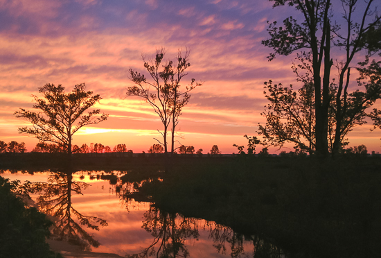
Sunset at Pungo Lake in the Pocosin Lakes National Wildlife Refuge, Washington County, N.C. By 1990, forestry biologists judged that 97% of the East Dismal Swamp had not only been logged, but, after decades of drainage work and repeated burnings, converted into farmland or pine plantations. At the time of that study, the remaining 3% of the East Dismal’s forests were owned by lumber companies and were being actively drained and cut. If you go there today, it is hard to imagine that it was once the site of a vast and majestic swamp forest. It is also difficult, I think, to remember the thousands of men and women who found homes in the old lumber boomtowns along the Pungo and who toiled in its logging camps and mills. I dedicate this story to them, and to the memory of the great swamp. Photo courtesy, Roads End Naturalist

Did you know that Lake Waccamaw cypress shingles went to Mt. Vernon in 1914 and remained on the roof until (I think) the 40s? When I was at the museum, I discovered that tidbit and the women’s group from Mt. Vernon sent me some info. Very interesting piece, David! Ginger Littrell
Sent from my iPhone
LikeLike
David–your documentation of how the topography of northeast North Carolina was destroyed in the late 1800s and early 1900s is both amazing and heartbreaking. Thank you for this tribute to man’s ingenuity and to the paradise that we lost
LikeLike
Dear David, This was fascinating. Thank you! Paul and I have taken many trips to that area, camping and exploring. Till now our only knowledge of all that commercial logging came from Ron Rash’s wonderful novel Serena.
Returned a day ago after 6 months in Vermont. Lots of work done there but much more to go! Planning our full-time move there in spring. Now to downsize and paint here, after I recover gardens from a summer of weeds.
Let us know when you are in the area…. Thanks again, Susan
Susan DeWitt Wilder (she/her) 207.730.0574 Davis, NC and Perkinsville, VT
LikeLike
I boat, fish and live around this area. Excellent history of turn of the 20th century. It also chronicles the sad loss of forest instead of lumbering sustainably
LikeLike
Another great article David.
LikeLiked by 1 person
I value every one of your deeply researched eastern NC histories. I’ve relished many days in the Pungo and surrounding areas for all my life, but with only a cursory knowledge of your revelations. The tragic deforestation echoes similar tragedies in Burns’ recent Buffalo series – same decades, same shortsighted motives, same disregard of environment and inhabitants. I am grateful for your scholarship and the op to share with others.
LikeLiked by 1 person
Thank you so much for taking the time to write, Molly. And for your kind words. Both mean a lot to me. David
LikeLike
Came across this story searching for something else and gave it a quick read and scroll through the photos. If you would like I have some family photos from the 1910′-20’s from where my Great Grandfather was a foreman for one of the crews in the Dismal in Gates County, NC extending up in Suffolk, VA. We have 2 of the narrow gauge rails with the train at the loader with the crew posed for a photo.
LikeLike
Josh– I’d love to them! Do you have digital copies? If you do, you could send them to my email– david.s.cecelski@gmail.com. Or if you don’t, maybe you can email me at that email address and we can work something else out. Thanks for thinking of me! Also, I wonder if you have any family stories about your great-grandfather’s work in the Dismal? I’d love to hear them! Thanks again!
LikeLike