The U.S. Army Corps of Engineers’ pipe-line dredge Currituck off the North Carolina coast, February 1931. Source: Office of History, HQ, U.S. Army Corps of Engineers
I have recently been absorbed by a photograph album that the staff at the U.S. Army Corps of Engineers’ (USACE’s) Office of History discovered in their historical collections a few years ago.
The name of the photographer who took the photographs in the album is not known, but they are a treasure.
Dating from 1930 to 1932, the album’s photographs make up a rare, up-close portrait of USACE dredging crews and dredge boats engaged in maintaining and improving navigation on the hundreds of miles of coastal waterways between Norfolk, Va., and Beaufort, N.C.
That 200-mile stretch of coastline composed the USACE’s “Norfolk District,” which was headquartered in Norfolk.
The whole album is fascinating. However, my favorite scenes are probably a series of photographs from the Scuppernong River in the spring of 1931. They chronicle the crew of one of USACE’s derrick barges clearing snags, dynamiting obstructions, and straightening the banks along the narrow, upper reaches of the river.

The Scuppernong River rises in the eastern part of Washington County, N.C., and flows through Tyrrell County (highlighted here) and into the Albemarle Sound. In 1930, the largest town on the Scuppernong was Columbia, the seat of Tyrrell County, population 864. Map, courtesy of Wikipedia
Dredging on a small, remote, out-of-the-way blackwater river such as the Scuppernong was a bread and butter job for USACE in those early years of the Great Depression. However, I can’t remember ever seeing that kind of work captured so fully in photographs.
Overall, the photographs are quite varied. The album even includes, for instance, a half-dozen photographs of USACE’s big pipe-line dredge Currituck barreling through Beaufort Inlet on its way to build a new section of the Intracoastal Waterway.
In my experience, those of us who study maritime history rarely give much attention to dredging crews and their watercraft .
Working on a dredge boat was hard, dirty work, a bit like being a sailor, a bit like being a miner, a bit like being a heavy equipment operator, and a bit like being a pipe fitter and a mechanic too.
The crews often lived on their boats for months at a time. They were not getting rich, and they moved from work site to work site, getting home, if they had a home, when they could.
Throughout the 20th century, many dredging crews all over the East Coast came from villages on the North Carolina coast.
They came from some coastal communities more than others. At Ocracoke Island, on the Outer Banks, for instance, or in Otway, in the Down East part of Carteret County, you would have been hard pressed to find a single family that did not have a father or a son who had not worked on a dredge boat at one time or another.

For more on Ocracoke Islanders and the dredging industry, see my story “Ocracoke and Philadelphia– An Outer Banks Village, a Great Seaport and the Bond between Them.” This photograph shows Delaware Avenue, Philadelphia, with the Delaware River and Benjamin Franklin Bridge in the background, early 20th century. Courtesy, kienantimberlake.org
The USACE’s Norfolk District Photo Album, 1931-32 includes 99 photographs in all. You can now find them all on-line at USACE’s Digital Library.
I have picked out a selection of the photographs to highlight here. You will find them below, along with my annotations about the places, people, and activities depicted in them.
I have also included an especially striking photograph taken on the deck of the USACE dredge Currituck that I found at the Mariners’ Museum in Newport News, Virginia.
It is an up-close view of the Currituck’s cutterhead, the mammoth dredging tool that her crew used to dig much of the Intracoastal Waterway along the North Carolina coast.
(The Mariners Museum, by the way, has copies of the USACE’s photographs in its library. You can access them here.)
I don’t think this is the time to discuss the overall historical impact of the U.S. Army Corps of Engineers on the North Carolina coast, either for the good or the bad.
However, I think that I should note that few entities, of any kind, have shaped either the geography or economy of the North Carolina coast more over the last 150 years.
Resting in the hands of the USACE’s dredging crews and those of its private contractors has been the very shape of our coastline and the character of much of maritime life and work.
That has included the depths and commercial viability of our harbors; the fate of our seaports; how far our rivers can be navigated; which inlets are navigable and which are not; where ferries can run, and where they cannot; where boats can find refuge; how vulnerable, or not, coastal towns are to hurricanes; and where, if at all, our commercial fishing fleets can get to sea, among much else.
In those same hands, again for better and for worse, has been the fates of whole coastal ecosystems.

Another page of the photo album shows the aftermath of the fire that ravaged Norfolk’s waterfront on June 7, 1931. Courtesy, Office of History, HQ, U.S. Army Corps of Engineers
Yet in all my years of studying the history of the North Carolina coast, I have never seen a book, a museum exhibit, or a historical marker about that part of our maritime heritage.
Many a time I have looked out onto a harbor or an inlet and watched a dredging crew at work and wondered what their lives were like, and how they do what they do, and what it is like to endeavor to shape and bend the sea and shore against nature’s will.
Of course, the photographs in the USACE’s Norfolk District Photo Album, 1931-32 are far from the full story.
They only show us a brief moment in history, and just a few waterways. But to me they are still invaluable: at the very least, they give us a glimpse of this usually unseen part of our maritime history and leave us with a yearning to know more.
* * *
The following is a selection of the album’s photographs and a little background on what is happening in them.
-1-

This is the U.S. Army Corps of Engineers’ derrick barge No. 14 at work on Turner’s Cut, a canal in Camden County, N.C., September 1931. Turner’s Cut was originally dug in the 1850s, apparently by slave labor. The 4.4-mile canal was designed so that vessels headed north to, or leaving south from, the Dismal Swamp Canal would no longer have to traverse a shallow, narrow, and winding section of the Upper Pasquotank River that was known as the “Moccasin Track.” Still in use today, the Cut runs from South Mills, N.C., at the southern end of the Dismal Swamp Canal, to a broader, more navigable point on the Pasquotank closer to Elizabeth City. In this photograph, the No. 14’s crew is removing a 2,500-foot-long shoal that had built up just below the canal lock at South Mills. Source: Office of History, HQ, U.S. Army Corps of Engineers
-2-

Derrick barge No. 14 widening Turner’s Cut, September, 1931. Source: Office of History, HQ, U. S. Army Corps of Engineers
-3-

This is the contract dredge Reliance on Knobbs Creek, June 1931. Knobbs Creek is a freshwater stream that flows into the Pasquotank River some 18 miles north of the river’s mouth on the Albemarle Sound. The Reliance’s crew spent several months dredging a 10-foot-deep channel and turning basin there. Prior to its dredging, Knobbs Creek’s channel was too narrow for lumber barges to turn around, meaning they had to be towed stern-first one way or the other. Owned by the Norfolk Dredging Company, the Reliance had been doing work for the Army Corps of Engineers on the North Carolina coast for decades. The first mention that I found of her in local newspapers was from the 15th of September, 1913. On that date, The Virginian-Pilot reported that the Reliance had sunk on the Pamlico River in a powerful hurricane that had come ashore at Cape Lookout two days earlier. She was soon refloated and back to work. Source: Office of History, HQ, U.S. Army Corps of Engineers
-4-
Here we see derrick barge No. 14 on a section of the Scuppernong River near Creswell, N.C., May 1931. According to the U.S. Army’s Report of the Chief of Engineers for 1931, the dredge’s crew spent 3 months that year removing snags from the upper part of the Scuppernong and trimming and straightening the river’s bank. The Scuppernong is a roughly 30-mile-long blackwater river that rises in eastern Washington County, crosses into Tyrrell County and flows into Bull Bay, on the south side of the Albemarle Sound. Prior to the 1870s, the head of navigation for steamers on the Scuppernong was a site called Spruills Bridge, 23 miles from the river’s mouth. Over the next half century, the Corps’ dredges extended navigation a little more than 2 miles farther upriver, into a narrow, winding section of the river near the community of Cherry. During those years, Corps dredges also doubled the depth of the river’s bar and did a good deal of channel dredging, including excavating a 10-foot channel from the river’s bar to the town of Columbia. Source: Office of History, HQ, U.S. Army Corps of Engineers
-5-
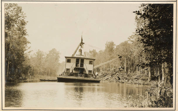
Stern view of derrick barge No. 14 on the Scuppernong River, May 1931. According to the Corps’ annual report, the barge’s crew removed 22,152 cubic yards of earth, roots, and stumps in and along the banks of the Scuppernong that spring. Source: Office of History, HQ, U.S. Army Corps of Engineers
-6-
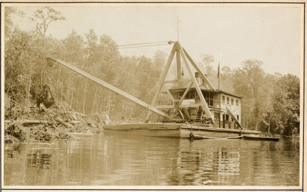
Here we can see derrick barge No. 14’s orange-peel bucket cutting off a point of land that was protruding into the Scuppernong River, May 1931. An “orange-peel bucket” is a kind of bucket dredge with three or four jaws (or shells) that open and grab earth and vegetation and then close around them. The bucket hangs from a pair of wires or chains that dangle from the end of the dredge’s boom and whose operation is powered by a double cylinder, double drum steam engine. On No. 14, the hoist operator used those wires to lower and raise the bucket, open and close the bucket’s jaws, and to turn the boom so that the bucket’s contents could be deposited onto a scow or, as in this case, onto the banks of the Scuppernong. Source: Office of History, HQ, U.S. Army Corps of Engineers
-7-
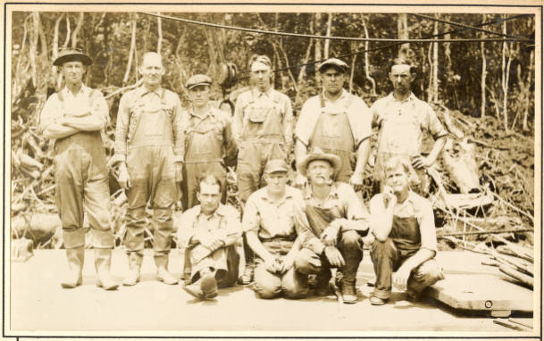
This is derrick barge No. 14’s crew on the banks of the Scuppernong, May 1931. Any job in that early part of the Great Depression was a good job, but a dredge crewman’s life was no bed of roses. Dredge crews worked long hours, typically seven days a week, lived on the boat, and were often away from home for months at a time. On the other hand, the job came with a regular paycheck, and at least now and then dredge boatmen had the chance to socialize with the locals. Over the years, in fact, I’ve heard many a story of romance between dredge boatmen and local women, including a story involving my family. My grandmother’s brother, Douglass Sabiston, of Core Creek, N.C., worked on one of the Army Corps’ dredge boats building the Intracoastal Waterway (IWW) through North and South Carolina in the 1930s. He met my great-aunt Dessie while building a section of the IWW near her family’s farm outside of Monck’s Corner, S.C. Source: Office of History, HQ, U.S. Army Corps of Engineers
-8-
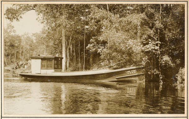
This is the launch Long Point, which served as the tender for derrick barge No. 14 while she was working on the Scuppernong River, May 1931. The No. 14’s crew used the Long Point in a variety of ways, including towing the dredge boat from work site to work site and making runs upriver to the town of Columbia to get groceries and other supplies. Source: Office of History, HQ, U.S. Army Corps of Engineers
-9-

The Long Point and another tender towing the derrick barge No. 14, ca. 1931-32, place unknown, but somewhere in the Army Corps of Engineers’ Norfolk District. Source: U.S. Corps of Engineers Digital Library
-10-
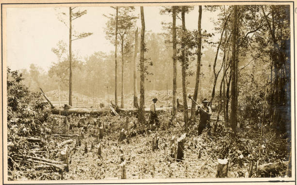
To straighten the Scuppernong, No. 14’s crew sometimes went ashore and removed points of land that formed bends in the river. In those cases, as we can see here, they usually cut down the trees on that piece of land before they started dredging. Source: Office of History, HQ, U.S. Army Corps of Engineers
-11-
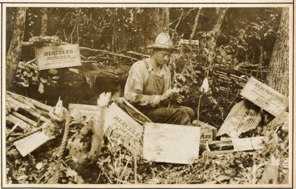
In this photo, we see one of No. 14’s crewmen preparing dynamite on the banks of the Scuppernong River, May 1931. Judging by the box labels, he was using dynamite produced by the Hercules Powder Co. and the Atlas Powder Company, two of the three chemical and munitions companies that were formed when the federal courts broke up DuPont’s munitions monopoly in 1911-12. Dynamite was widely used in river dredging. In this case, No. 14’s crew was blasting a point that protruded into the river to make the river straighter and easier to navigate. In other cases, dredge crews used dynamite to clear tree stumps (usually the remnants of bald cypress swamps), that were in the river. That was most commonly done for the sake of navigation, but was sometimes done to make a river or sound bottom suitable for a seine fishery. Before the Civil War, historical accounts sometimes referred to seine fishery owners forcing enslaved African American divers to lay explosive charges in submerged cypress stumps. (For more on that topic, see my book The Waterman’s Song.) Source: Office of History, HQ, U.S. Army Corps of Engineers
-12-
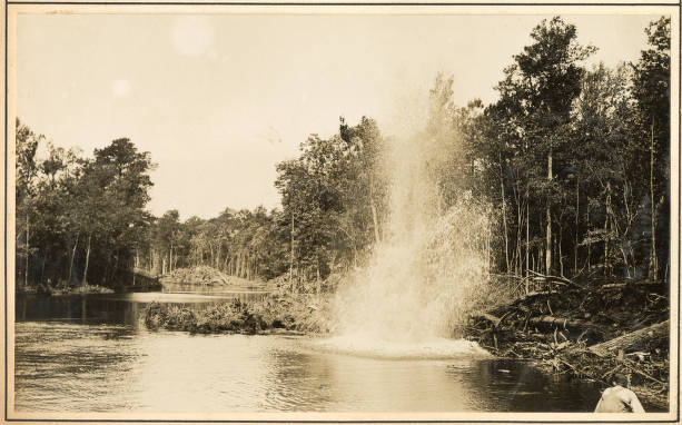
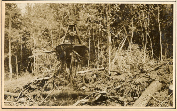
Here we can see one of the dynamite blasts that the No. 14’s crew used to uproot stumps, roots, and earth and straighten the Scuppernong River, May 1931. After uprooting the largest stumps and breaking up the earth with dynamite, the crewmen would get to work with the dredge barge’s bucket. Source: Office of History, HQ, U.S. Army Corps of Engineers
-13-
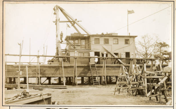
In this photo, we can see a man standing above No. 14’s deck, apparently working on its A-frame, February 1932. At the time, the barge was in dry dock for repairs and maintenance at a boatyard in Elizabeth City, N.C. She had had a busy year in 1931. In addition to working on the waterways seen in these photographs, she had also undertaken at least 2 other large projects: clearing snags and other obstructions along a 35-mile-long stretch of the Roanoke River, and removing shoals and clearing obstructions on a 12-mile-long segment of the Meherrin River, between the river’s mouth and Murfreesboro. In September 1931, No. 14 had also had a brief stint clearing mud, roots, and logs out of the Dismal Swamp Canal’s lock in South Mills, N.C. Source: Office of History, HQ, U. S. Army Corps of Engineers
-14-
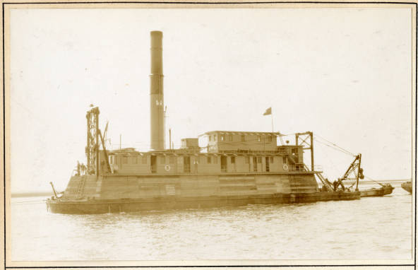
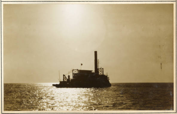
This is the U.S. Army Corps of Engineers’ pipe-line dredge Currituck crossing the bar at Beaufort Inlet, February 1931. By the time of this photograph, the Currituck had been working on and around the North Carolina coast for nearly 20 years. At 197-feet in length and 1,000 tons, she was a far larger vessel than the other dredges featured in the Norfolk District Photo Album. In the 1920s and ’30s, the Currituck took the lead in building large sections of the Intracoastal Waterway, including the 22-mile-long canal that runs from the Pungo River to the Alligator River. According to the 1931 edition of Merchant Vessels of the United States, the Currituck typically carried six officers and a crew of 33. The high column midship is the dredge’s main spud, a pipe-like shaft built through the boat’s hull. When dredging, the boat’s crew lowered that spud and drove it into the bottom of whatever body of water they were working on to moor the craft and hold it steady. Source: Office of History, HQ, U.S. Army Corps of Engineers
-15-

This intimidating bit of machinery is a cutterhead (a.k.a. “rotary cutter”) resting on the deck of the Currituck in 1932. As you can see, this is a very different beast than the bucket dredge that we saw being used on derrick barge No. 14. Attached to the inlet end of a hydraulic dredge’s suction pipe, this cutterhead was a powerful, rotating instrument that broke up and then sucked in sand, mud, rock, and pretty much everything else at a dredging site. The dredge’s centrifugal pumps carried the loose material into pipes, which in turn carried the material to a dump site– either a barge for transport elsewhere or to a dredge spoil island or shoreline nearby. This photograph comes from the W. W. Old Collection at the Mariners Museum, Newport News, Va.
-16-

This is a smaller hydraulic suction dredge working on the North River, just east of Beaufort, N.C., in Sept. 1931. In all likelihood, the dredge is making or maintaining a channel for the use of menhaden steamers and other commercial fishing boats. The dredge may have been the Neveral, which in those days seemed to do the bulk of the harbor dredging, channel clearing, and a little bit of everything else in the Beaufort vicinity. (That included the rather imposing amount of dredge work that was necessary to build the 2.3-mile-long bridge that connected Beaufort and Morehead City in 1927). At the time of this photograph, the Neveral was owned and operated by the Coastal Construction Company, but was under contract to the Corps of Engineers. As we can see, her crew has laid piping along a series of pontoons to transport the dredge spoil to land. Source: Office of History, HQ, U.S. Army Corps of Engineer
-17-
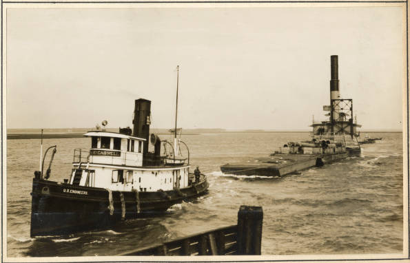
A final look at the Army Corps of Engineers’ crews at work. In this photograph, we see the Corps’ tug Richard Caswell towing the pipe-line dredge Currituck at Beaufort, N.C., February 1931. The tug’s crew has its hands full: the Caswell has towed the Currituck south down the Intracoastal Waterway (IWW) and the two vessels are now approaching the Norfolk & Southern Railroad’s bridge in a stiff northeast wind and a roiling tide. They made it, but only after tying up the Currituck’s pontoons on the bridge escarpment and then having the tug go back and retrieve them after the Currituck made it to the other side. The Richard Caswell was one of several tugs that towed dredge boats and barges for the Army Corps of Engineers’ Norfolk District. Like all tugs, she was a stout, seaworthy craft, and her 9-man crew had to be tough sailors who knew their jobs. Built in Southport, N.C., in 1913, the Caswell was an 84.9 ft.-long tug with a displacement of 200 tons. On the day shown here, she was leading the Currituck to a rendezvous with a larger, oceangoing tug on the other side of the Beaufort Bar. That tug would take her south of Wilmington to begin work on a new section of the IWW. Source: Office of History, HQ, U.S. Army Corps of Engineers

This is fascinating. Thank you for sharing your research.
LikeLike
I grew up on Davis Shore and often heard the story of the time during World War II when the Army Corps of Engineers had to enlist the help of Mr. Denard Davis and his mule Nell when they were attempting to install gun implacements on Core Banks due to the Germans being off the coast. As the story goes, the ACOE was having trouble because their moving equipment kept sinking in the sand. Then someone yelled out, “Go get Denard Davis and Nell” (Mr. Denard and Nell were well known for moving houses). Mr. Denard put Nell on a boat, and off they went to the Banks and got the job done. Mr. Denard used to take Nell to plow up gardens for folks on Davis, and as a small child, I can remember being so excited when Nell passed by.
LikeLike
Fascinating article as usual. Thank you.
LikeLike
You continue to amaze, this time dredging up history/photos that may well have been lost to all but for your meticulous research.
LikeLike
I found your blog by accident, while trying to find maps of the Scuppernong River in Washington County, NC. My grandfather worked on a barge in the latter part of the 1930s into the 1940s. It was a 3 man crew – him and two others, and they would head to their barge early Monday mornings and then return home late Friday nights. They made their way from either where the Scuppernong River meets Maul Creek or at Spruills Bridge, and to the mouth of the river, using dynamite to deepen the river. They also worked on the canals that ran from Lake Phelps to the river. There was one time when the dynamite crew on the land by one of the canals was having difficulty with removing a tree stump. My grandfather told the commanding officer that he could remove it, and they man replied that if he did that, then he’d get the pay of the man who was supposed to be handling it. My grandfather studied the stump for a few minutes, then prepared and set his charge, and blew it out of the ground. For one day, he had better pay.
Looking at the photos you share here about the dredging in 1931, I believe that my grandfather is in the photograph of the crew. If I’m right, and it’s him, then it explains how he learned how to dynamite and clear land. Another avenue to explore, as I had no idea he might have been employed by the Army Corps of Engineers, and now wonder if that was his employer later that decade (one of my uncles thought it was the CCC, but I’ve not found any evidence to support that).
Thank you for sharing these photos.
LikeLike
I’m so happy you found this story– and I’m very excited that you think your grandfather might be in the photograph of the crew! That’s wonderful! Gracious, I would have loved to sit with him and listened to his stories about those days on the Scuppernong!
LikeLike
Thanks to someone posting the photo of the #14 derrick dredge crew in a local genealogy group, I believe I now have a photo of my husband’s grandfather! He was born in Georgia, and it was told that he was working on the dredge when he met his future wife in Tyrrell County. The US 14 crew photo is dated May 13, 1931, and they were married on May 30, 1931! His nickname was “Shorty,” so after looking at the photo, I may have him figured out. Now to find someone still living who knew him to tell me if I’m correct.
This article was really fascinating for me, as my maternal roots run deep in that area of North Carolina, and the information you provided is just great! Thank you!
LikeLike
I love hearing stories like yours! I think that kind of romance happened a lot with the dredging crews. I had a great-uncle and aunt that met when he was working on a dredge boat digging the Intracoastal Waterway– it was a very rural area and she said they didn’t get very many visitors until the dredge crews showed up! Thanks for writing!
LikeLike
The large pipe in center of the dredge Currituck is the exhaust pipe they were steam dredges. the frame on the stern called a spud frame held two spuds.
LikeLike
I appreciate the correction– sounds like you know your way around a steam dredge. Were you on them a good while?
LikeLike