
Cattle grazing in the shadow of the Cape Hatteras Lighthouse, Cape Hatteras, N.C., ca. 1900. Image by Albert Ross, USN. Courtesy, Linda Garey
Linda Garey, a teacher I met some years ago, recently sent me copies of some remarkable historical images of North Carolina lighthouses and lightships that were taken in and around 1899. They are from her great-grandfather Rear Admiral Albert Ross’s extraordinary collection of magic lantern glass slides that he made while serving in the U.S. Navy.
Rear Admiral Ross had a long and distinguished naval career. After first enrolling at the Naval Academy during the Civil War, he served in the Navy all the way through the First World War.
During that time, he commanded naval vessels in many of the world’s seas. Late in his career, he also taught at the Naval Academy, commanded the naval training vessel Alliance and served in a variety of other roles related to the training of sailors.

Rear Admiral Albert Ross (5th from left) was still serving in the U.S. Navy two decades after his visit to the North Carolina coast. Here he is standing with officers of the USS Intrepid at the Mare Island Navy Yard in California in 1919. Courtesy, U.S. Naval History and Heritage Command
Perhaps most significantly, he oversaw the construction of the Great Lakes Naval Station, which is still the navy’s largest training facility. He also served as the facility’s first commanding officer.
Between roughly 1898 and 1902, Rear Admiral Ross was also in charge of inspecting and maintaining lighthouses, lightships and other navigational aides in the U.S. Lighthouse Board’s Fifth District.
He made these images during that time. The Fifth District covered the coastal waters from Chesapeake Bay to Cape Lookout, N.C., so periodically he made inspection tours throughout that area, including the Outer Banks and the estuaries on their western sides.
Rear Admiral Ross’s glass lantern slides provide a fresh look at those lighthouses and lightships and give us a unique glimpse into the maritime world in which he spent his life.
The Lightship Diamond Shoals 69
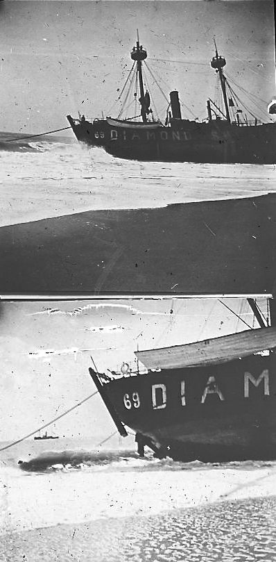
The lightship Diamond Shoals 69 aground on Hatteras Island, 1899. Photo by Albert Ross, USN. Courtesy, Linda Garey
In our first two images, we see the lightship Diamond Shoal 69 aground on Hatteras Island, N.C., in August 1899. A two-masted, schooner-rigged steam vessel with no bowsprit, she was usually moored in roughly 180 feet of water 15 miles SE of the Cape Hatteras Lighthouse.
In better times, the Diamond Shoal 69 warned seagoing vessels away from the waters of the “Graveyard of the Atlantic” with two sets of 3 electric lanterns set in a circle around her mastheads.
The storm that drove her ashore was the great “San Ciriaco” hurricane of August 1899.
On August 18, 1899, the storm pounded the lightship mercilessly. The force of the wind and waves either broke the lightship’s mooring or forced the captain to raise the vessel’s anchor so that he could steer into the great wall of waves better and try to ride out the storm.
The powerful winds and those mountainous waves, however, overwhelmed the Diamond Shoal 69’s steam engine and drove her ashore on Hatteras Island.
The surfmen at the Creeds Hill U.S. Life-Saving Station reached the battered lightship two hours later and succeeded in rescuing the crew. At the time, waves were breaking over her deck.
The Diamond Shoal 69 was the second of seven lightships stationed at Diamond Shoals, some of the most dangerous waters for shipping on the country’s Atlantic coast.
The first lightship was a 320-ton vessel that was on duty off and on in 1822-24. In June 1824, however, a hurricane blew her onto the beach.
The U.S. Lighthouse Board attempted to build a lighthouse on Diamond Shoal in 1891. However, the board’s members chose to station lightships on the shoals instead after a storm scattered the construction vessels and destroyed the unfinished and already damaged structure.
After being towed to port and repaired, the Diamond Shoal 69 alternated with a newly-built lightship, the Diamond Shoal 71, to protect shipping in the waters off Cape Hatteras.
The Diamond Shoal 69 was hardly the only victim of the San Ciriaco hurricane. Reports indicate that 10 feet of water covered all of Hatteras Island, killing horses and livestock and sweeping away homes and boats.
More than 50 ships wrecked between Currituck and Cape Fear, and at least another half-dozen disappeared at sea.
The number of deaths due to the storm is uncertain, but one estimate put the number at around sixty, including 20 fishermen off Ocracoke Island and 16 sailors that perished crossing Pamlico Sound.
Laurel Point Lighthouse

Laurel Point Lighthouse, Albemarle Sound, N.C., ca. 1900. Image by Albert Ross, USN. Courtesy, Patricia Garey
This is a rare image of the Laurel Point Lighthouse, a hexagonal, screw-pile lighthouse (built on pilings) on the Albemarle Sound. Outfitted with a fourth order Fresnel lens that flashed white every 30 seconds, the lighthouse went into operation in January 1880 and was not discontinued until the 1950s.
The lighthouse stood in 9 feet of water approximately a mile N/NE of Laurel Point, which is located on the south side of the Albemarle Sound, 10 miles west of Columbia, N.C. (Tyrrell County).
The Laurel Point Lighthouse was one of at least eight screw-pile lighthouses built on North Carolina’s sounds in the 1800s. One other, the Bluff Shoal Lighthouse, was built in 1904.
Between 1893 and 1896, Albemarle Sound had a series of exceptionally cold winters. The sound froze from shore to shore at least once, which was very unusual, and at other times ice flows collided with the lighthouse’s screw-piles.
During those winters, the Laurel Point Lighthouse’s records indicate that the ice repeatedly damaged its seven screw-piles. The damage led to extensive repairs and to the construction of a buffer of pilings designed to keep flow ice from damaging the screw-piles further.
The Cape Hatteras Light
The Cape Hatteras Lighthouse, Hatteras Island, ca. 1900. The lantern at the top of the pole in the foreground, raised and lowered by pulleys, is probably a range light. Aligning the range light and the lighthouse beacon aided mariners to fix their position in the night sea.

Cape Hatteras, N.C., ca 1899-1900. Image by Albert Ross, USN. Courtesy, Linda Garey
A horse and a well-dressed man, standing in a high-wheeled cart, are looking up the beach.
He may be one of the lighthouse keepers, aspiring to look his best because a U.S. Navy commander (our photographer, Albert Ross) has come from Baltimore to inspect his lighthouse.
Construction of the lighthouse began in November 1868. It was no small business to build a lighthouse, and especially not one as grand as the Capt Hatteras Lighthouse.
Before they could even get to the actual construction of the foundation and tower, the workers had to build a small village.

Another view of the Cape Hatteras Lighthouse and keeper’s quarters, this time surrounded by floodwaters. This was probably soon after the San Ciricao hurricane in August 1899. Image by Albert Ross, USN. Courtesy, Linda Garey
Around the site, they built barracks and a mess hall, a blacksmith shop and supply sheds. They also constructed wharves on the island’s sound side, so they could unload the massive amounts of brick, stone and lumber necessary to build the lighthouse and its keeper’s quarters.
In addition, they built a tram railway to carry those building materials and other supplies across the island to the construction site.
“The most imposing and substantial brick lighthouse on this continent, if not in the world,” my old friend David Stick wrote in his classic The Outer Banks of North Carolina. He was quoting an engineer’s report at the time.
First lit on December 16, 1870, the lighthouse was 208 feet from top to bottom, the lantern was 184 feet above sea level and the ascent to the light was a climb of 268 steps.
At that time, the ocean was still far from the lighthouse. It may have been as much as ½ mile to the east.
By the late 20th century, Cape Hatteras’s powerful winds, tides and currents had washed away so much of the beach that, if the lighthouse had not been moved in 1999, it would have soon fallen into the sea.
Lightship Diamond Shoal 72

The lightship Diamond Shoals 72 in waters off Cape Hatteras, N.C., ca. 1900. Image by Albert Ross, USN. Courtesy, Linda Garey
The lightship Diamond Shoal 72, another of the lightships that was moored in the Atlantic approximately 15 miles SE of Cape Hatteras. She often alternated her station with the lightship Diamond Shoal 71, the two vessels taking turns, three months on and three months off.
Built at the Fore River Shipyard in Quincy, Mass., in 1900, the Diamond Shoal 72 was the first steel hulled lightship ever built. When launched, she was 125’ 6’ long, 23’6’’ wide and carried a 350 horsepower, single cylinder engine.
Lightship duty was always dangerous. There was the danger of hurricanes or other storms breaking the lightship’s mooring and driving it onto a shoal or beach, as happened with the Diamond Shoal 69.
But there was also the danger of collisions with freighters, tankers and other large vessels that, in that era before radar or satellite navigation systems, might not see the lightship in a storm or fog.
The National Lightship Sailors Memorial in New Bedford, Mass., attests to the dangers of lightship duty.
War posed a different kind of danger to lightships. During the First World War, for instance, a German submarine sank the Diamond Shoal 72’s sister lightship, the Diamond Shoal 71, off of Cape Hatteras.
The sub’s commander allowed the Diamond Shoal 71’s crew to abandon the vessel and man lifeboats prior to its destruction.
Channel Lights and Buoys

A lighted channel marker at an unknown locale in the U.S. Lighthouse Board’s 5th District. Photo by Albert Ross, USN. Courtesy, Linda Garey
In this lantern slide, we see one of Rear Admiral Ross’s crew inspecting and perhaps re-fueling a lighted channel marker, having left his skiff tied up below. The scene is somewhere in the U.S. Lighthouse Board’s 5th District. Rear Admiral Ross’s notes do not indicate the locale, but it sure looks a lot like Coinjock Bay or another part of Currituck Sound.
In addition to lighthouses and lightships, Rear Admiral Ross also inspected and oversaw the maintenance of channel markers, buoys and other navigational aides that helped to protect vessels from dangerous shoals and guide them through the region’s waters.
Rear Admiral Ross had a great interest in navigational markers. His collection of lantern slides includes many diagrams, drawings and photographs related to the design and functioning of buoys, markers and lights.
The Albemarle & Chesapeake Canal

Gas channel marker, Albemarle & Chesapeake Canal (probably the section of the canal on Currituck Sound), ca. 1900. Image by Albert Ross, USN. Courtesy, Linda Garey
In this lantern slide, we see a gas beacon channel marker somewhere on the North Carolina part of the Albemarle and Chesapeake Canal. This scene does not look like the “North Carolina Cut” with its narrow, straight banks, so I assume that the marker stood in Currituck Sound or the North River.
You can find my 7-part series on Rear Admiral Ross’s journey through the Albemarle and Chesapeake Canal here.
Bodie Island Lighthouse

Bodie Island Lighthouse, Bodie Island, N.C., ca. 1900. Image by Albert Ross, USN. Courtesy, Linda Garey
The Bodie Island Lighthouse and keeper’s quarters, ca. 1900. The man standing with a horse is the foreground is either the lighthouse keeper at the time, George A. Bliven, or one of his two assistants.
Built in 1872, the lighthouse was 156 feet high, had 214 iron steps and was painted with black and white horizontal bands. A leading Paris maker, Barbiere and Fenestre, manufactured the lighthouse’s first order Fresnel lens.
Barbiere and Fenestre supplied more than 450 lenses to lighthouses in the U.S. between 1862 and the early 1900s.
On a clear night, that lens made the Bodie Island Lighthouse’s beacon visible to mariners on ships as far as 18 nautical miles out to sea.
Currituck Beach Lighthouse

Currituck Beach Lighthouse and keeper’s quarters, Corolla, N.C., ca. 1900. Image by Albert Ross, USN. Courtesy, Linda Garey
In this glass lantern slide, we see the Currituck Beach Lighthouse and keeper’s quarters in the hamlet of Corolla, N.C. ca. 1900. The little settlement was located on a section of Currituck Banks known as Whalehead, after the shape of a large sand dune.
Built in 1875, the lighthouse provided the only beacon for an 80-mile stretch of coastline between Cape Henry, Va., and Bodie Island, N.C.
On a dark night, mariners would find few lights of any kind on those shores and the light at Currituck Beach was an especially welcome sight.
Built of brick, the lighthouse was 5’ 8’’ thick at the base and had an iron stairway that ascended 214 steps. The tower was left unpainted (unique among the state’s lighthouses) and had a lighting sequence of 5 seconds of red “flash” (made my projecting the beacon through ruby red glass) and 85 seconds of steady light.
Every lighthouse of course had to have a unique appearance (“daymark”) and a distinct lighting sequence or seamen might not recognize what shore they were approaching.
The Currituck Beach Lighthouse complex occupied a remote corner of the Outer Banks, but it did not lack for society when Rear Admiral Ross inspected the lighthouse.
Three families occupied the keeper’s quarters at that time.
The keeper, William J. Simmons, his wife Lela P. Simmons and possibly all 5 of their children lived in 3 rooms on the building’s south side.
Two other families, neither small, resided in the 3 rooms on the other side. Assistant keeper William Riley Austin, his wife Lovey Peele Austin and their children (7 in all) were there.
They shared the 3 rooms with William’s brother Wesley, who was the other assistant keeper, along with his wife Belle and their children (8 in all).
The chief keeper’s wife, Lela Simmons, was one of the rare few women that the U.S. Lighthouse Board ever appointed to a keeper’s position.
Lela Simmons’ husband had previously been the chief keeper at the Brant Island Shoal Lighthouse, one of the screw-pile lighthouses on Pamlico Sound. While there, Lela Simmons was briefly the 2nd assistant keeper.
(I should note: while not officially keepers, many other women did perform some or even all of the keeper’s duties. That was especially true when their husbands were injured or ill. In those cases, however, they did so unofficially and without pay.)
To learn more about the history of the Currituck Beach Lighthouse and its keepers, I strongly recommend the web site for the Outer Banks Conservationists (OBC), which now operates the lighthouse as a historic site and museum.
I also highly recommend a book published by the OBC and available for free on line, Jenny Edwards’ To Illuminate the Dark Space: Oral Histories of the Currituck Beach Lighthouse.
Special thanks to Meghan Agresto, the site manager at the Currituck Beach Lighthouse, for so generously sharing her knowledge of the lighthouse’s history with me.
Cape Lookout Lighthouse

Cape Lookout Lighthouse, Cape Lookout, N.C., ca. 1900. Image by Albert Ross, USN. Courtesy, Linda Garey
Lastly, this is of course the Cape Lookout Lighthouse and its keeper’s quarters, located at Cape Lookout on the southern end of Core Banks, near where I grew up.
First lit in November 1859, the lighthouse is 163 feet high and its first order Fresnel lens originally shown steady without blinking. (Today another beacon flashes every 15 seconds.)
The U.S. Lighthouse Board had the lighthouse painted with its now famous black and white diagonal checkered daymark in the 1870s.
Diamond City, the largest settlement on Shackleford Banks in the late 1800s, was named after that pattern of checker marks, or diamonds, on the lighthouse.
Today Shackleford Banks, the former site of Diamond City, is just across an inlet from the lighthouse. When Rear Admiral Ross visited the lighthouse, however, you could walk from the lighthouse to Diamond City. The great 1933 storm opened an inlet between the two sites.
At the time of Rear Admiral Ross’s inspection tour, Diamond City and the other communities on Shackleford Banks had just recently been abandoned. Like the lightship Diamond Shoals 69 in the two photographs that we looked at earlier, the islanders were victims of the great San Ciriaco hurricane in 1899.
Still standing proudly at Cape Lookout today, the lighthouse is a strong testament to the way that coastal people sometimes embrace a local lighthouse and find in it a powerful symbol of higher things.
If you drive through those local communities near where I grew up today, you will see the Cape Lookout Lighthouse’s image on countless car license plates. You will find miniature versions of the lighthouse in many yards, and you will discover its image etched onto scores of gravestones.
-End-
Special thanks to Linda Garey for sharing her great-grandfather’s lantern slides and for giving me permission to use them here.

Wonderful. It will be awhile before I can read it all. Now I am ashamed because I need to migrate those albums, including the light-houses, from the dumb Google product to Flickr. That will have to wait for a break from the academic year.
A timely post just after the big storm!
LikeLiked by 2 people
Also, this collection were among the first boxes I transferred, so I was still developing a technique. Later I got much better at dumping the images into a Photoshop type program and manipulating the contrast and focus for a better image. These could be improved. I had to invent everything I did. There are hobbyists in the UK who collect the lantern slides, very few here, and very little shared information on transferring to digital. Even the most professional scanner is really set up for our 35mm product, so it was all trial and error at first.
LikeLiked by 2 people
Linda Garey is my daughter and I am so proud that she shared these slides with you. You explain the complete history very well and it is indeed interesting. Thanks so much. Zelda Garey Dubel, Fresno, CA.
LikeLiked by 1 person
Ms. Dubel, thank you so much for your note. Admiral Ross’s lantern slides are such a treasure, it felt like a great, great privilege to study them and tell a little part of their stories. It is also very, very fortunate to me that they have had such a careful and dedicated curator in your daughter Linda– I think that is very rare. So many important historical sources are lost because they do not have someone who recognizes their value and is willing to make the commitment to preserve them. Thank you again for writing. David Cecelski
LikeLike
David, thanks for sharing Linda’s collection of slides. My grandfather, Luey Angel Midgett, was a crew member on Diamond Shoals 69 when she came ashore near Creed’s Hill during the San Ciriaco storm. I had heard family stories about the storm and the distress that his family endured during the storm and their worry and concern over Luey’s fate. After a brief recovery at the Creed’s Hill station, he walked the 3 miles home to Hatteras and surprised everyone that he had survived. What a treasure these images are.
Thank you Linda Garey.
Ray Midgett
LikeLiked by 1 person
Ray- this is a truly awesome story! Wow! Thanks for sharing it! I sure would have enjoyed talking with your granddad!
LikeLike